You are here: Home > Network List > US - United States National Seismic Network Stations List
> Station NEW Newport, Washington, USA > Earthquake Result Viewer
NEW Newport, Washington, USA - Earthquake Result Viewer
*The percent match for this event was below the threshold and hence no stack was calculated.
| Earthquake location: |
Near Islands, Aleutian Islands |
| Earthquake latitude/longitude: |
53.1/173.0 |
| Earthquake time(UTC): |
2011/09/14 (257) 18:10:09 GMT |
| Earthquake Depth: |
15 km |
| Earthquake Magnitude: |
6.1 MB, 5.7 MS, 6.0 MW, 6.0 MW |
| Earthquake Catalog/Contributor: |
WHDF/NEIC |
|
| Network: |
US United States National Seismic Network |
| Station: |
NEW Newport, Washington, USA |
| Lat/Lon: |
48.26 N/117.12 W |
| Elevation: |
760 m |
|
| Distance: |
42.9 deg |
| Az: |
67.08 deg |
| Baz: |
303.793 deg |
| Ray Param: |
$rayparam |
*The percent match for this event was below the threshold and hence was not used in the summary stack. |
|
| Radial Match: |
78.87024 % |
| Radial Bump: |
400 |
| Transverse Match: |
72.28523 % |
| Transverse Bump: |
400 |
| SOD ConfigId: |
558545 |
| Insert Time: |
2013-09-19 02:52:36.766 +0000 |
| GWidth: |
2.5 |
| Max Bumps: |
400 |
| Tol: |
0.001 |
|
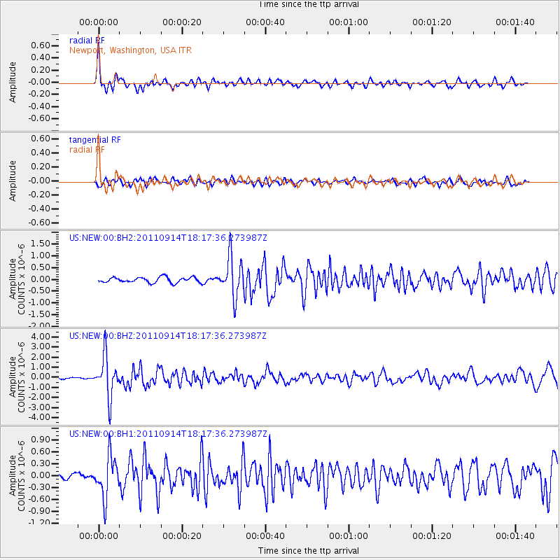
Signal To Noise
| Channel | StoN | STA | LTA |
| US:NEW:00:BHZ:20110914T18:17:36.273987Z | 16.198862 | 2.0757284E-6 | 1.2814037E-7 |
| US:NEW:00:BH1:20110914T18:17:36.273987Z | 7.0748467 | 5.336872E-7 | 7.543445E-8 |
| US:NEW:00:BH2:20110914T18:17:36.273987Z | 7.4894924 | 8.6905163E-7 | 1.1603613E-7 |
| Arrivals |
| Ps | |
| PpPs | |
| PsPs/PpSs | |


