You are here: Home > Network List > IU - Global Seismograph Network (GSN - IRIS/USGS) Stations List
> Station JOHN Johnston Island, USA > Earthquake Result Viewer
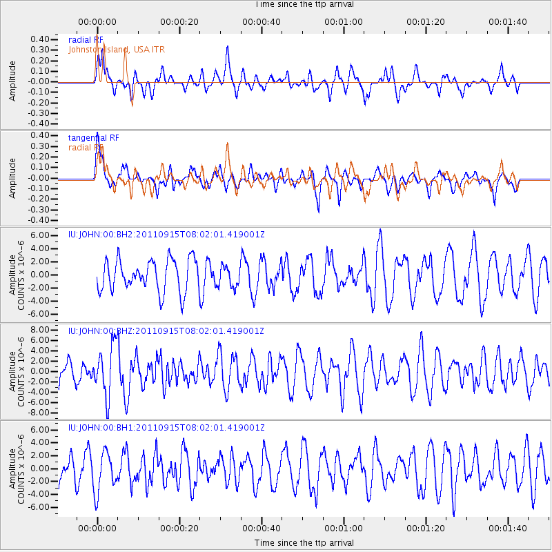
JOHN Johnston Island, USA - Earthquake Result Viewer
*The percent match for this event was below the threshold and hence no stack was calculated.
| Earthquake location: |
East Of North Island, N.Z. |
| Earthquake latitude/longitude: |
-35.4/-179.0 |
| Earthquake time(UTC): |
2011/09/15 (258) 07:53:18 GMT |
| Earthquake Depth: |
10 km |
| Earthquake Magnitude: |
6.0 MB, 6.2 MS, 6.1 MW, 6.0 MW |
| Earthquake Catalog/Contributor: |
WHDF/NEIC |
|
| Network: |
IU Global Seismograph Network (GSN - IRIS/USGS) |
| Station: |
JOHN Johnston Island, USA |
| Lat/Lon: |
16.73 N/169.53 W |
| Elevation: |
2.0 m |
|
| Distance: |
52.6 deg |
| Az: |
11.496 deg |
| Baz: |
189.787 deg |
| Ray Param: |
$rayparam |
*The percent match for this event was below the threshold and hence was not used in the summary stack. |
|
| Radial Match: |
47.822865 % |
| Radial Bump: |
400 |
| Transverse Match: |
65.16492 % |
| Transverse Bump: |
400 |
| SOD ConfigId: |
558545 |
| Insert Time: |
2013-09-19 02:54:06.217 +0000 |
| GWidth: |
2.5 |
| Max Bumps: |
400 |
| Tol: |
0.001 |
|
Signal To Noise
| Channel | StoN | STA | LTA |
| IU:JOHN:00:BHZ:20110915T08:02:01.419001Z | 2.1307287 | 4.9669347E-6 | 2.3310968E-6 |
| IU:JOHN:00:BH1:20110915T08:02:01.419001Z | 1.5439222 | 3.1387692E-6 | 2.0329842E-6 |
| IU:JOHN:00:BH2:20110915T08:02:01.419001Z | 0.66327494 | 1.6001494E-6 | 2.412498E-6 |
| Arrivals |
| Ps | |
| PpPs | |
| PsPs/PpSs | |


