You are here: Home > Network List > CN - Canadian National Seismograph Network Stations List
> Station INK INUVIK, NT, CANADA.ANADA > Earthquake Result Viewer
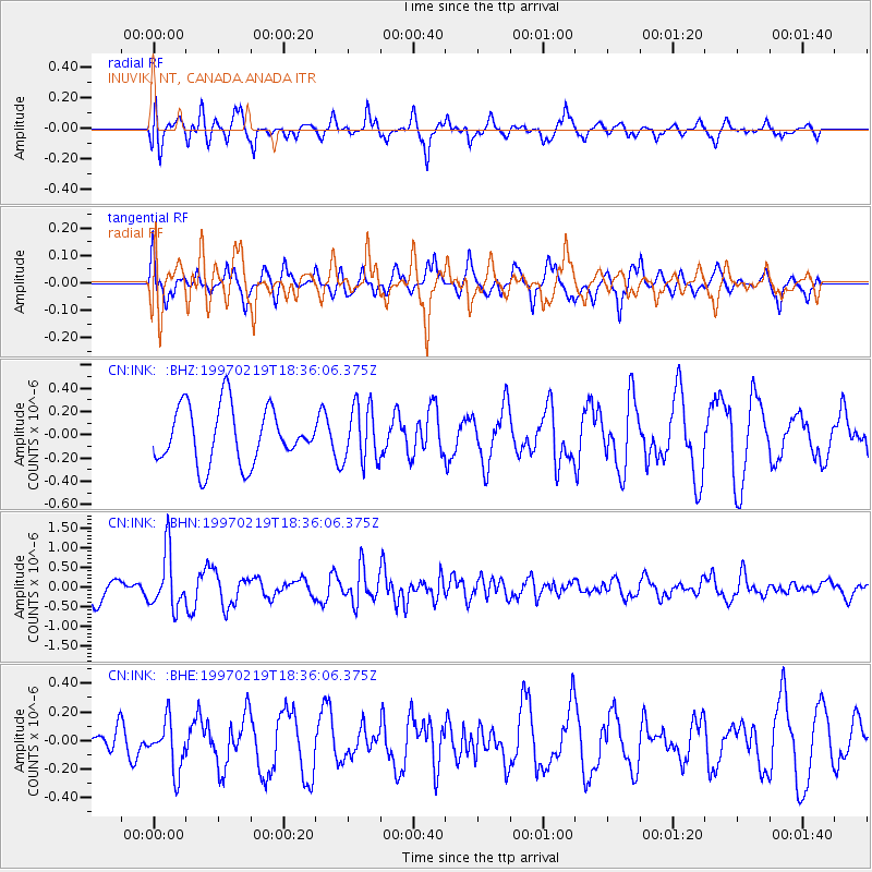
INK INUVIK, NT, CANADA.ANADA - Earthquake Result Viewer
*The percent match for this event was below the threshold and hence no stack was calculated.
| Earthquake location: |
Colombia |
| Earthquake latitude/longitude: |
4.6/-76.5 |
| Earthquake time(UTC): |
1997/02/19 (050) 18:25:12 GMT |
| Earthquake Depth: |
101 km |
| Earthquake Magnitude: |
5.5 MB, 5.8 UNKNOWN, 5.7 MW |
| Earthquake Catalog/Contributor: |
WHDF/NEIC |
|
| Network: |
CN Canadian National Seismograph Network |
| Station: |
INK INUVIK, NT, CANADA.ANADA |
| Lat/Lon: |
68.31 N/133.52 W |
| Elevation: |
40 m |
|
| Distance: |
74.0 deg |
| Az: |
341.07 deg |
| Baz: |
119.558 deg |
| Ray Param: |
$rayparam |
*The percent match for this event was below the threshold and hence was not used in the summary stack. |
|
| Radial Match: |
71.761734 % |
| Radial Bump: |
400 |
| Transverse Match: |
72.026596 % |
| Transverse Bump: |
369 |
| SOD ConfigId: |
4480 |
| Insert Time: |
2010-02-27 06:24:43.328 +0000 |
| GWidth: |
2.5 |
| Max Bumps: |
400 |
| Tol: |
0.001 |
|
Signal To Noise
| Channel | StoN | STA | LTA |
| CN:INK: :BHN:19970219T18:36:06.375Z | 2.6390152 | 7.1327014E-7 | 2.7027892E-7 |
| CN:INK: :BHE:19970219T18:36:06.375Z | 1.3455147 | 1.7452902E-7 | 1.2971172E-7 |
| CN:INK: :BHZ:19970219T18:36:06.375Z | 1.0056117 | 2.433727E-7 | 2.420146E-7 |
| Arrivals |
| Ps | |
| PpPs | |
| PsPs/PpSs | |


