You are here: Home > Network List > CN - Canadian National Seismograph Network Stations List
> Station INK INUVIK, NT, CANADA.ANADA > Earthquake Result Viewer
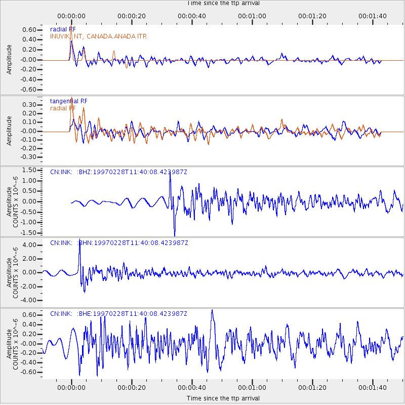
INK INUVIK, NT, CANADA.ANADA - Earthquake Result Viewer
*The percent match for this event was below the threshold and hence no stack was calculated.
| Earthquake location: |
Kuril Islands |
| Earthquake latitude/longitude: |
43.9/147.9 |
| Earthquake time(UTC): |
1997/02/28 (059) 11:32:18 GMT |
| Earthquake Depth: |
33 km |
| Earthquake Magnitude: |
6.1 MB, 5.5 MS, 5.9 UNKNOWN, 5.7 MW |
| Earthquake Catalog/Contributor: |
WHDF/NEIC |
|
| Network: |
CN Canadian National Seismograph Network |
| Station: |
INK INUVIK, NT, CANADA.ANADA |
| Lat/Lon: |
68.31 N/133.52 W |
| Elevation: |
40 m |
|
| Distance: |
46.0 deg |
| Az: |
30.447 deg |
| Baz: |
279.964 deg |
| Ray Param: |
$rayparam |
*The percent match for this event was below the threshold and hence was not used in the summary stack. |
|
| Radial Match: |
77.358376 % |
| Radial Bump: |
400 |
| Transverse Match: |
73.543884 % |
| Transverse Bump: |
400 |
| SOD ConfigId: |
4480 |
| Insert Time: |
2010-02-27 06:24:45.103 +0000 |
| GWidth: |
2.5 |
| Max Bumps: |
400 |
| Tol: |
0.001 |
|
Signal To Noise
| Channel | StoN | STA | LTA |
| CN:INK: :BHN:19970228T11:40:08.423987Z | 9.027653 | 1.5236935E-6 | 1.6878069E-7 |
| CN:INK: :BHE:19970228T11:40:08.423987Z | 2.5461001 | 2.7665595E-7 | 1.0865871E-7 |
| CN:INK: :BHZ:19970228T11:40:08.423987Z | 5.575958 | 5.8835604E-7 | 1.05516584E-7 |
| Arrivals |
| Ps | |
| PpPs | |
| PsPs/PpSs | |


