You are here: Home > Network List > US - United States National Seismic Network Stations List
> Station AGMN Agassiz National Wildlife Refuge, Minnesota, USA > Earthquake Result Viewer
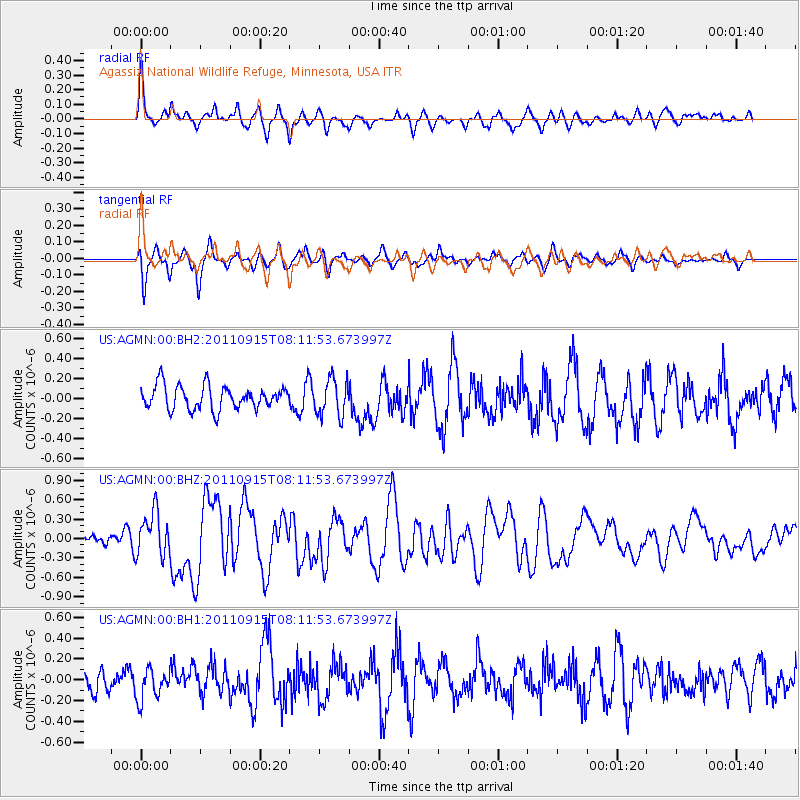
AGMN Agassiz National Wildlife Refuge, Minnesota, USA - Earthquake Result Viewer
*The percent match for this event was below the threshold and hence no stack was calculated.
| Earthquake location: |
Near East Coast Of Honshu, Japan |
| Earthquake latitude/longitude: |
36.3/141.3 |
| Earthquake time(UTC): |
2011/09/15 (258) 08:00:09 GMT |
| Earthquake Depth: |
28 km |
| Earthquake Magnitude: |
5.8 MB, 6.0 MS, 6.2 MW, 6.1 MW |
| Earthquake Catalog/Contributor: |
WHDF/NEIC |
|
| Network: |
US United States National Seismic Network |
| Station: |
AGMN Agassiz National Wildlife Refuge, Minnesota, USA |
| Lat/Lon: |
48.30 N/95.86 W |
| Elevation: |
351 m |
|
| Distance: |
81.6 deg |
| Az: |
34.566 deg |
| Baz: |
316.626 deg |
| Ray Param: |
$rayparam |
*The percent match for this event was below the threshold and hence was not used in the summary stack. |
|
| Radial Match: |
66.272285 % |
| Radial Bump: |
400 |
| Transverse Match: |
70.53885 % |
| Transverse Bump: |
380 |
| SOD ConfigId: |
558545 |
| Insert Time: |
2013-09-19 02:56:41.883 +0000 |
| GWidth: |
2.5 |
| Max Bumps: |
400 |
| Tol: |
0.001 |
|
Signal To Noise
| Channel | StoN | STA | LTA |
| US:AGMN:00:BHZ:20110915T08:11:53.673997Z | 2.653509 | 3.4222288E-7 | 1.2896993E-7 |
| US:AGMN:00:BH1:20110915T08:11:53.673997Z | 1.6330333 | 1.4880469E-7 | 9.112165E-8 |
| US:AGMN:00:BH2:20110915T08:11:53.673997Z | 1.5708086 | 1.837271E-7 | 1.16963385E-7 |
| Arrivals |
| Ps | |
| PpPs | |
| PsPs/PpSs | |


