You are here: Home > Network List > US - United States National Seismic Network Stations List
> Station AMTX Amarillo, Texas, USA > Earthquake Result Viewer
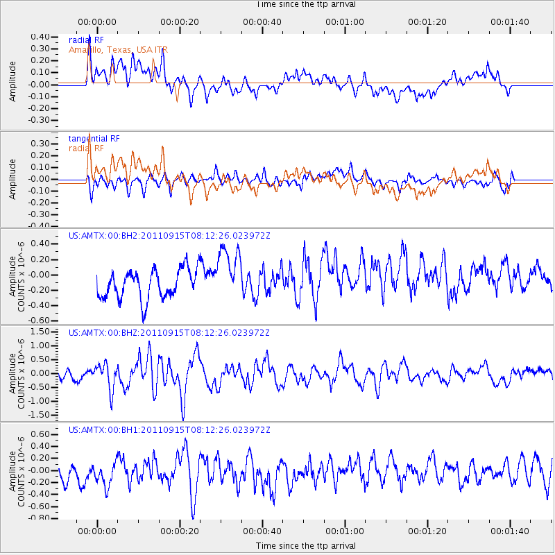
AMTX Amarillo, Texas, USA - Earthquake Result Viewer
*The percent match for this event was below the threshold and hence no stack was calculated.
| Earthquake location: |
Near East Coast Of Honshu, Japan |
| Earthquake latitude/longitude: |
36.3/141.3 |
| Earthquake time(UTC): |
2011/09/15 (258) 08:00:09 GMT |
| Earthquake Depth: |
28 km |
| Earthquake Magnitude: |
5.8 MB, 6.0 MS, 6.2 MW, 6.1 MW |
| Earthquake Catalog/Contributor: |
WHDF/NEIC |
|
| Network: |
US United States National Seismic Network |
| Station: |
AMTX Amarillo, Texas, USA |
| Lat/Lon: |
34.53 N/101.41 W |
| Elevation: |
1010 m |
|
| Distance: |
88.5 deg |
| Az: |
47.24 deg |
| Baz: |
314.045 deg |
| Ray Param: |
$rayparam |
*The percent match for this event was below the threshold and hence was not used in the summary stack. |
|
| Radial Match: |
53.102417 % |
| Radial Bump: |
400 |
| Transverse Match: |
46.936306 % |
| Transverse Bump: |
400 |
| SOD ConfigId: |
558545 |
| Insert Time: |
2013-09-19 02:56:45.102 +0000 |
| GWidth: |
2.5 |
| Max Bumps: |
400 |
| Tol: |
0.001 |
|
Signal To Noise
| Channel | StoN | STA | LTA |
| US:AMTX:00:BHZ:20110915T08:12:26.023972Z | 2.3222084 | 4.7563898E-7 | 2.0482184E-7 |
| US:AMTX:00:BH1:20110915T08:12:26.023972Z | 1.1479609 | 2.8877076E-7 | 2.5155103E-7 |
| US:AMTX:00:BH2:20110915T08:12:26.023972Z | 1.4194417 | 2.7092213E-7 | 1.9086528E-7 |
| Arrivals |
| Ps | |
| PpPs | |
| PsPs/PpSs | |


