You are here: Home > Network List > CN - Canadian National Seismograph Network Stations List
> Station INK INUVIK, NT, CANADA.ANADA > Earthquake Result Viewer
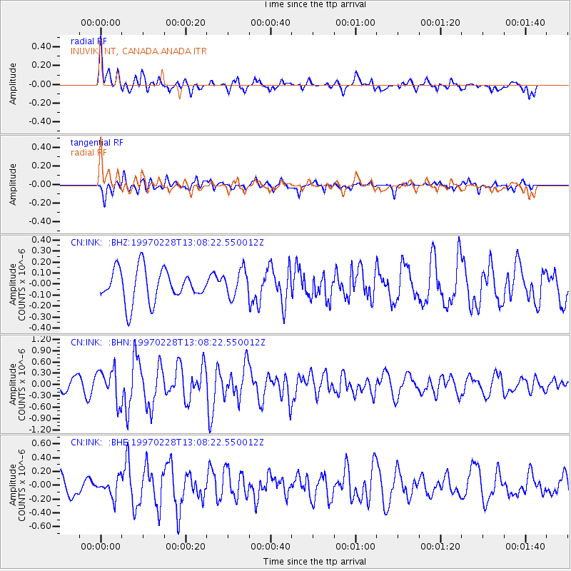
INK INUVIK, NT, CANADA.ANADA - Earthquake Result Viewer
*The percent match for this event was below the threshold and hence no stack was calculated.
| Earthquake location: |
Armenia-Azerbaijan-Iran Bord Reg |
| Earthquake latitude/longitude: |
38.1/48.0 |
| Earthquake time(UTC): |
1997/02/28 (059) 12:57:18 GMT |
| Earthquake Depth: |
10 km |
| Earthquake Magnitude: |
5.5 MB, 6.1 MS, 6.1 UNKNOWN, 6.0 MW |
| Earthquake Catalog/Contributor: |
WHDF/NEIC |
|
| Network: |
CN Canadian National Seismograph Network |
| Station: |
INK INUVIK, NT, CANADA.ANADA |
| Lat/Lon: |
68.31 N/133.52 W |
| Elevation: |
40 m |
|
| Distance: |
73.9 deg |
| Az: |
0.607 deg |
| Baz: |
358.711 deg |
| Ray Param: |
$rayparam |
*The percent match for this event was below the threshold and hence was not used in the summary stack. |
|
| Radial Match: |
66.92242 % |
| Radial Bump: |
400 |
| Transverse Match: |
69.09143 % |
| Transverse Bump: |
400 |
| SOD ConfigId: |
4480 |
| Insert Time: |
2010-02-27 06:24:51.698 +0000 |
| GWidth: |
2.5 |
| Max Bumps: |
400 |
| Tol: |
0.001 |
|
Signal To Noise
| Channel | StoN | STA | LTA |
| CN:INK: :BHN:19970228T13:08:22.550012Z | 3.0012743 | 4.3571657E-7 | 1.4517718E-7 |
| CN:INK: :BHE:19970228T13:08:22.550012Z | 0.75250024 | 1.3440109E-7 | 1.7860603E-7 |
| CN:INK: :BHZ:19970228T13:08:22.550012Z | 0.83059746 | 1.2243717E-7 | 1.4740856E-7 |
| Arrivals |
| Ps | |
| PpPs | |
| PsPs/PpSs | |


