You are here: Home > Network List > US - United States National Seismic Network Stations List
> Station SCIA State Center, Iowa, USA > Earthquake Result Viewer
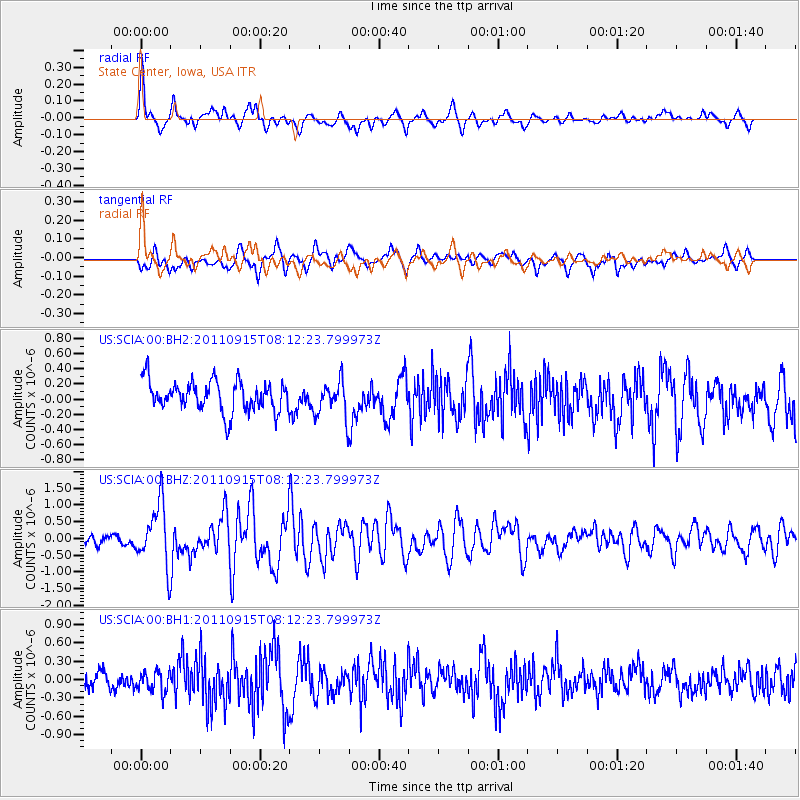
SCIA State Center, Iowa, USA - Earthquake Result Viewer
*The percent match for this event was below the threshold and hence no stack was calculated.
| Earthquake location: |
Near East Coast Of Honshu, Japan |
| Earthquake latitude/longitude: |
36.3/141.3 |
| Earthquake time(UTC): |
2011/09/15 (258) 08:00:09 GMT |
| Earthquake Depth: |
28 km |
| Earthquake Magnitude: |
5.8 MB, 6.0 MS, 6.2 MW, 6.1 MW |
| Earthquake Catalog/Contributor: |
WHDF/NEIC |
|
| Network: |
US United States National Seismic Network |
| Station: |
SCIA State Center, Iowa, USA |
| Lat/Lon: |
41.91 N/93.22 W |
| Elevation: |
312 m |
|
| Distance: |
87.6 deg |
| Az: |
37.491 deg |
| Baz: |
318.773 deg |
| Ray Param: |
$rayparam |
*The percent match for this event was below the threshold and hence was not used in the summary stack. |
|
| Radial Match: |
63.881687 % |
| Radial Bump: |
400 |
| Transverse Match: |
61.072403 % |
| Transverse Bump: |
400 |
| SOD ConfigId: |
558545 |
| Insert Time: |
2013-09-19 02:57:55.662 +0000 |
| GWidth: |
2.5 |
| Max Bumps: |
400 |
| Tol: |
0.001 |
|
Signal To Noise
| Channel | StoN | STA | LTA |
| US:SCIA:00:BHZ:20110915T08:12:23.799973Z | 2.5205798 | 9.036248E-7 | 3.584988E-7 |
| US:SCIA:00:BH1:20110915T08:12:23.799973Z | 0.9122502 | 1.6504244E-7 | 1.8091795E-7 |
| US:SCIA:00:BH2:20110915T08:12:23.799973Z | 1.1709602 | 2.3480423E-7 | 2.0052282E-7 |
| Arrivals |
| Ps | |
| PpPs | |
| PsPs/PpSs | |


