You are here: Home > Network List > CN - Canadian National Seismograph Network Stations List
> Station INK INUVIK, NT, CANADA.ANADA > Earthquake Result Viewer
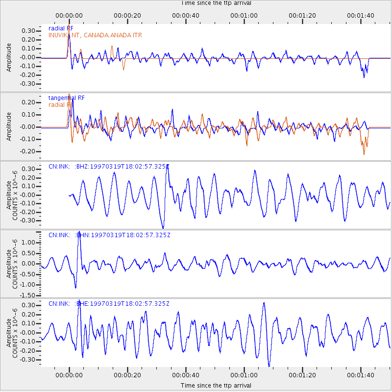
INK INUVIK, NT, CANADA.ANADA - Earthquake Result Viewer
*The percent match for this event was below the threshold and hence no stack was calculated.
| Earthquake location: |
Tonga Islands |
| Earthquake latitude/longitude: |
-16.6/-173.9 |
| Earthquake time(UTC): |
1997/03/19 (078) 17:50:42 GMT |
| Earthquake Depth: |
99 km |
| Earthquake Magnitude: |
5.5 MB, 5.7 UNKNOWN, 5.7 MW |
| Earthquake Catalog/Contributor: |
WHDF/NEIC |
|
| Network: |
CN Canadian National Seismograph Network |
| Station: |
INK INUVIK, NT, CANADA.ANADA |
| Lat/Lon: |
68.31 N/133.52 W |
| Elevation: |
40 m |
|
| Distance: |
89.6 deg |
| Az: |
13.937 deg |
| Baz: |
218.4 deg |
| Ray Param: |
$rayparam |
*The percent match for this event was below the threshold and hence was not used in the summary stack. |
|
| Radial Match: |
57.389534 % |
| Radial Bump: |
373 |
| Transverse Match: |
67.19191 % |
| Transverse Bump: |
369 |
| SOD ConfigId: |
4480 |
| Insert Time: |
2010-02-27 06:25:05.714 +0000 |
| GWidth: |
2.5 |
| Max Bumps: |
400 |
| Tol: |
0.001 |
|
Signal To Noise
| Channel | StoN | STA | LTA |
| CN:INK: :BHN:19970319T18:02:57.325Z | 4.517333 | 7.057325E-7 | 1.5622769E-7 |
| CN:INK: :BHE:19970319T18:02:57.325Z | 1.193738 | 1.6967256E-7 | 1.4213552E-7 |
| CN:INK: :BHZ:19970319T18:02:57.325Z | 1.8644272 | 2.3807065E-7 | 1.2769104E-7 |
| Arrivals |
| Ps | |
| PpPs | |
| PsPs/PpSs | |


