You are here: Home > Network List > IU - Global Seismograph Network (GSN - IRIS/USGS) Stations List
> Station PAYG Puerto Ayora, Galapagos Islands > Earthquake Result Viewer
PAYG Puerto Ayora, Galapagos Islands - Earthquake Result Viewer
| Earthquake location: |
Fiji Islands Region |
| Earthquake latitude/longitude: |
-21.6/-179.5 |
| Earthquake time(UTC): |
2011/09/15 (258) 19:31:04 GMT |
| Earthquake Depth: |
645 km |
| Earthquake Magnitude: |
6.1 MB, 7.3 MW, 7.3 MW |
| Earthquake Catalog/Contributor: |
WHDF/NEIC |
|
| Network: |
IU Global Seismograph Network (GSN - IRIS/USGS) |
| Station: |
PAYG Puerto Ayora, Galapagos Islands |
| Lat/Lon: |
0.67 S/90.29 W |
| Elevation: |
270 m |
|
| Distance: |
89.0 deg |
| Az: |
90.346 deg |
| Baz: |
248.528 deg |
| Ray Param: |
0.041583877 |
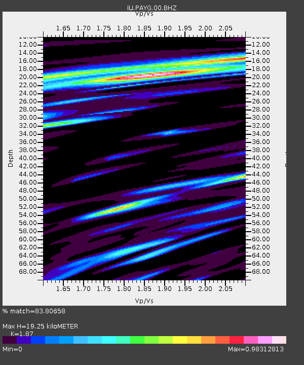
| Estimated Moho Depth: |
19.25 km |
| Estimated Crust Vp/Vs: |
1.87 |
| Assumed Crust Vp: |
4.802 km/s |
| Estimated Crust Vs: |
2.568 km/s |
| Estimated Crust Poisson's Ratio: |
0.30 |
|
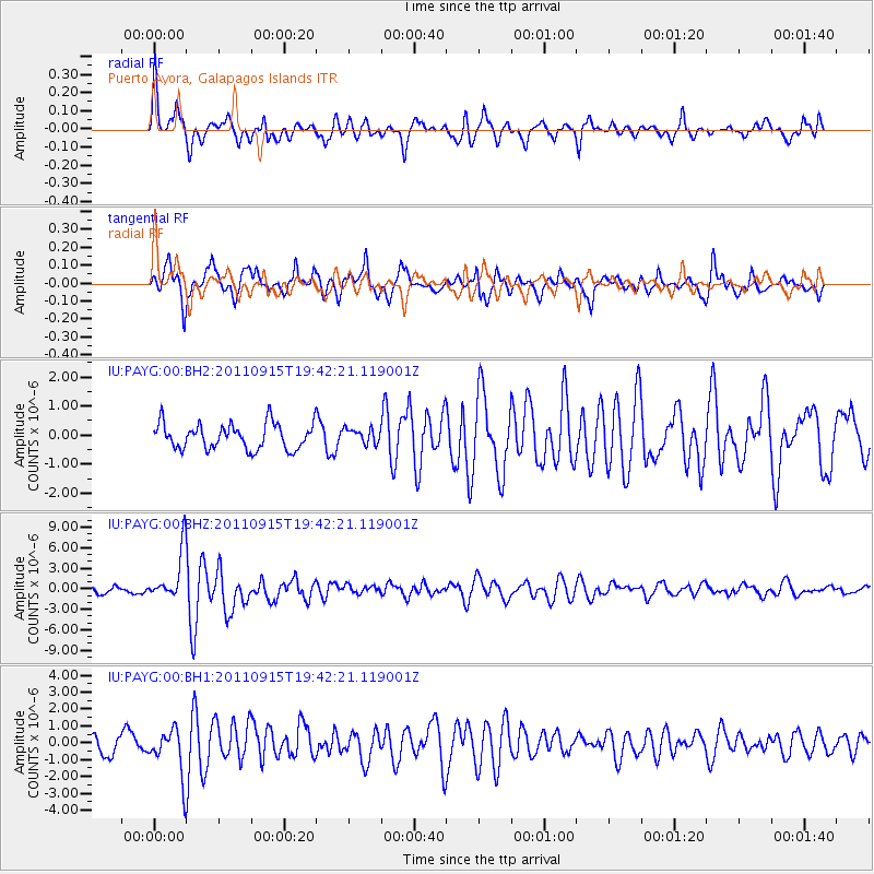
| Radial Match: |
83.80658 % |
| Radial Bump: |
400 |
| Transverse Match: |
85.17375 % |
| Transverse Bump: |
400 |
| SOD ConfigId: |
558545 |
| Insert Time: |
2013-09-19 03:01:48.568 +0000 |
| GWidth: |
2.5 |
| Max Bumps: |
400 |
| Tol: |
0.001 |
|
Signal To Noise
| Channel | StoN | STA | LTA |
| IU:PAYG:00:BHZ:20110915T19:42:21.119001Z | 7.0613894 | 3.6083677E-6 | 5.109997E-7 |
| IU:PAYG:00:BH1:20110915T19:42:21.119001Z | 2.451542 | 1.3796274E-6 | 5.6275906E-7 |
| IU:PAYG:00:BH2:20110915T19:42:21.119001Z | 0.5942257 | 2.6149047E-7 | 4.4005245E-7 |
| Arrivals |
| Ps | 3.5 SECOND |
| PpPs | 11 SECOND |
| PsPs/PpSs | 15 SECOND |


