You are here: Home > Network List > CN - Canadian National Seismograph Network Stations List
> Station INK INUVIK, NT, CANADA.ANADA > Earthquake Result Viewer
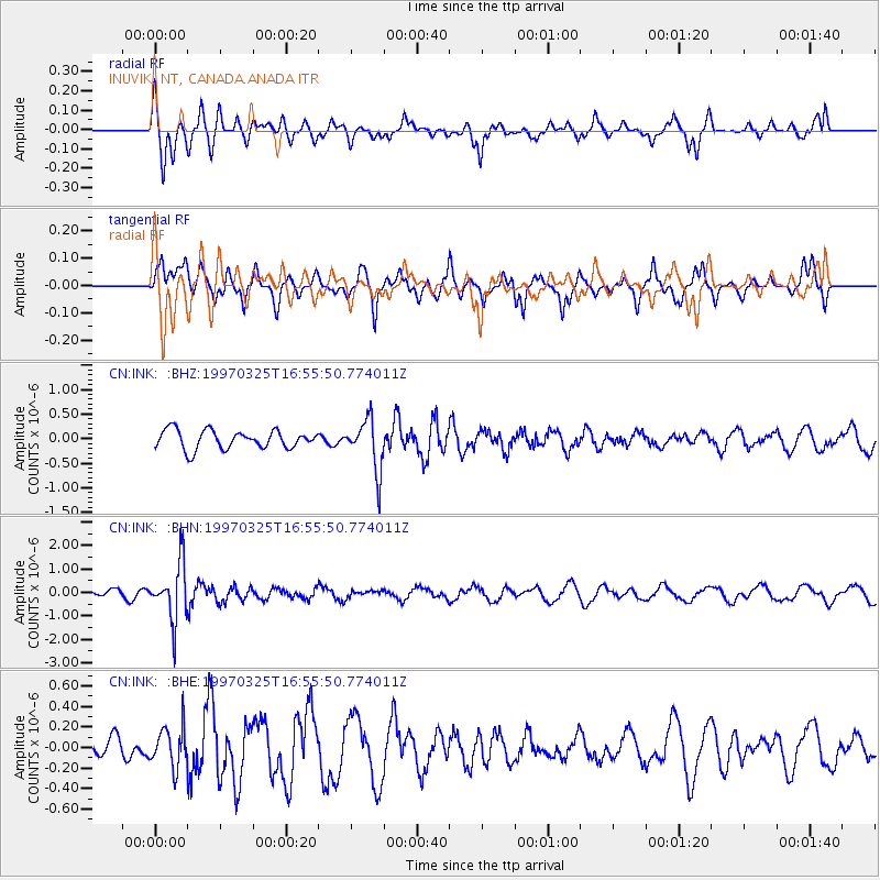
INK INUVIK, NT, CANADA.ANADA - Earthquake Result Viewer
*The percent match for this event was below the threshold and hence no stack was calculated.
| Earthquake location: |
Peru-Brazil Border Region |
| Earthquake latitude/longitude: |
-9.1/-71.3 |
| Earthquake time(UTC): |
1997/03/25 (084) 16:44:32 GMT |
| Earthquake Depth: |
603 km |
| Earthquake Magnitude: |
6.0 UNKNOWN, 5.4 MB, 6.0 MW |
| Earthquake Catalog/Contributor: |
WHDF/NEIC |
|
| Network: |
CN Canadian National Seismograph Network |
| Station: |
INK INUVIK, NT, CANADA.ANADA |
| Lat/Lon: |
68.31 N/133.52 W |
| Elevation: |
40 m |
|
| Distance: |
88.5 deg |
| Az: |
340.788 deg |
| Baz: |
119.052 deg |
| Ray Param: |
$rayparam |
*The percent match for this event was below the threshold and hence was not used in the summary stack. |
|
| Radial Match: |
53.891033 % |
| Radial Bump: |
364 |
| Transverse Match: |
63.09683 % |
| Transverse Bump: |
351 |
| SOD ConfigId: |
4480 |
| Insert Time: |
2010-02-27 06:25:20.310 +0000 |
| GWidth: |
2.5 |
| Max Bumps: |
400 |
| Tol: |
0.001 |
|
Signal To Noise
| Channel | StoN | STA | LTA |
| CN:INK: :BHN:19970325T16:55:50.774011Z | 3.5316849 | 1.1920088E-6 | 3.3751843E-7 |
| CN:INK: :BHE:19970325T16:55:50.774011Z | 1.3835558 | 1.92629E-7 | 1.3922748E-7 |
| CN:INK: :BHZ:19970325T16:55:50.774011Z | 2.784125 | 5.207114E-7 | 1.8702876E-7 |
| Arrivals |
| Ps | |
| PpPs | |
| PsPs/PpSs | |


