You are here: Home > Network List > US - United States National Seismic Network Stations List
> Station MSO Missoula, Montana, USA > Earthquake Result Viewer
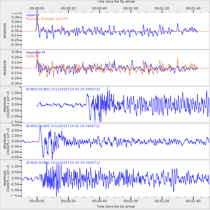
MSO Missoula, Montana, USA - Earthquake Result Viewer
*The percent match for this event was below the threshold and hence no stack was calculated.
| Earthquake location: |
Fiji Islands Region |
| Earthquake latitude/longitude: |
-21.6/-179.5 |
| Earthquake time(UTC): |
2011/09/15 (258) 19:31:04 GMT |
| Earthquake Depth: |
645 km |
| Earthquake Magnitude: |
6.1 MB, 7.3 MW, 7.3 MW |
| Earthquake Catalog/Contributor: |
WHDF/NEIC |
|
| Network: |
US United States National Seismic Network |
| Station: |
MSO Missoula, Montana, USA |
| Lat/Lon: |
46.83 N/113.94 W |
| Elevation: |
1264 m |
|
| Distance: |
90.1 deg |
| Az: |
38.699 deg |
| Baz: |
237.925 deg |
| Ray Param: |
$rayparam |
*The percent match for this event was below the threshold and hence was not used in the summary stack. |
|
| Radial Match: |
76.32936 % |
| Radial Bump: |
400 |
| Transverse Match: |
71.34077 % |
| Transverse Bump: |
400 |
| SOD ConfigId: |
558545 |
| Insert Time: |
2013-09-19 03:02:52.163 +0000 |
| GWidth: |
2.5 |
| Max Bumps: |
400 |
| Tol: |
0.001 |
|
Signal To Noise
| Channel | StoN | STA | LTA |
| US:MSO:00:BHZ:20110915T19:42:26.049971Z | 17.667582 | 1.5652047E-6 | 8.8591904E-8 |
| US:MSO:00:BH1:20110915T19:42:26.049971Z | 3.540097 | 2.730751E-7 | 7.713774E-8 |
| US:MSO:00:BH2:20110915T19:42:26.049971Z | 6.9024453 | 5.930982E-7 | 8.5925805E-8 |
| Arrivals |
| Ps | |
| PpPs | |
| PsPs/PpSs | |


