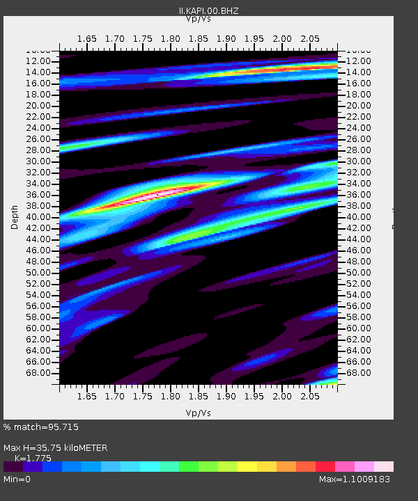
KAPI Kappang, Sulawesi, Indonesia - Earthquake Result Viewer

Earthquake location: Near East Coast Of Honshu, Japan
Earthquake latitude/longitude: 40.3/142.8
Earthquake time(UTC): 2011/09/16 (259) 19:26:40 GMT
Earthquake Depth: 35 km
Earthquake Magnitude: 6.0 MB, 6.5 MS, 6.7 MW, 6.7 MW
Earthquake Catalog/Contributor: WHDF/NEIC
Network: II Global Seismograph Network (GSN - IRIS/IDA)
Station: KAPI Kappang, Sulawesi, Indonesia
Lat/Lon: 5.01 S/119.75 E
Elevation: 300 m
Distance: 49.8 deg
Az: 210.684 deg
Baz: 23.075 deg
Ray Param: 0.06840913
Estimated Moho Depth: 35.75 km
Estimated Crust Vp/Vs: 1.77
Assumed Crust Vp: 6.343 km/s
Estimated Crust Vs: 3.574 km/s
Estimated Crust Poisson's Ratio: 0.27
Radial Match: 95.715 %
Radial Bump: 400
Transverse Match: 89.489006 %
Transverse Bump: 400
SOD ConfigId: 558545
Insert Time: 2013-09-19 03:05:26.056 +0000
GWidth: 2.5
Max Bumps: 400
Tol: 0.001

Signal To Noise

ChannelStoNSTALTA
II:KAPI:00:BHZ:20110916T19:34:59.468993Z12.7810931.158035E-69.060532E-8
II:KAPI:00:BH1:20110916T19:34:59.468993Z9.3157636.107509E-76.556101E-8
II:KAPI:00:BH2:20110916T19:34:59.468993Z3.82328942.7353013E-77.154314E-8
Arrivals
Ps4.6 SECOND
PpPs15 SECOND
PsPs/PpSs19 SECOND