You are here: Home > Network List > CN - Canadian National Seismograph Network Stations List
> Station INK INUVIK, NT, CANADA.ANADA > Earthquake Result Viewer
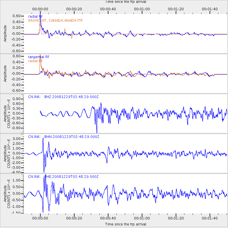
INK INUVIK, NT, CANADA.ANADA - Earthquake Result Viewer
*The percent match for this event was below the threshold and hence no stack was calculated.
| Earthquake location: |
Afghanistan-Tajikistan Bord Reg. |
| Earthquake latitude/longitude: |
36.4/71.1 |
| Earthquake time(UTC): |
2008/12/29 (364) 03:37:41 GMT |
| Earthquake Depth: |
158 km |
| Earthquake Magnitude: |
5.9 MB, 5.8 MW, 5.8 MW |
| Earthquake Catalog/Contributor: |
WHDF/NEIC |
|
| Network: |
CN Canadian National Seismograph Network |
| Station: |
INK INUVIK, NT, CANADA.ANADA |
| Lat/Lon: |
68.31 N/133.52 W |
| Elevation: |
40 m |
|
| Distance: |
74.0 deg |
| Az: |
9.264 deg |
| Baz: |
339.554 deg |
| Ray Param: |
$rayparam |
*The percent match for this event was below the threshold and hence was not used in the summary stack. |
|
| Radial Match: |
73.864174 % |
| Radial Bump: |
400 |
| Transverse Match: |
65.28937 % |
| Transverse Bump: |
400 |
| SOD ConfigId: |
2658 |
| Insert Time: |
2010-02-27 06:25:27.519 +0000 |
| GWidth: |
2.5 |
| Max Bumps: |
400 |
| Tol: |
0.001 |
|
Signal To Noise
| Channel | StoN | STA | LTA |
| CN:INK: :BHN:20081229T03:48:29.000Z | 7.5974855 | 1.4916315E-6 | 1.9633225E-7 |
| CN:INK: :BHE:20081229T03:48:29.000Z | 4.4579363 | 6.4267834E-7 | 1.44165E-7 |
| CN:INK: :BHZ:20081229T03:48:29.000Z | 4.0578117 | 3.9989212E-7 | 9.854872E-8 |
| Arrivals |
| Ps | |
| PpPs | |
| PsPs/PpSs | |


