You are here: Home > Network List > CN - Canadian National Seismograph Network Stations List
> Station INK INUVIK, NT, CANADA.ANADA > Earthquake Result Viewer
INK INUVIK, NT, CANADA.ANADA - Earthquake Result Viewer
*The percent match for this event was below the threshold and hence no stack was calculated.
| Earthquake location: |
Windward Islands |
| Earthquake latitude/longitude: |
11.4/-60.9 |
| Earthquake time(UTC): |
1997/04/02 (092) 06:14:31 GMT |
| Earthquake Depth: |
45 km |
| Earthquake Magnitude: |
5.8 MB, 5.5 MS, 6.2 UNKNOWN, 5.6 MD |
| Earthquake Catalog/Contributor: |
WHDF/NEIC |
|
| Network: |
CN Canadian National Seismograph Network |
| Station: |
INK INUVIK, NT, CANADA.ANADA |
| Lat/Lon: |
68.31 N/133.52 W |
| Elevation: |
40 m |
|
| Distance: |
73.0 deg |
| Az: |
338.232 deg |
| Baz: |
102.034 deg |
| Ray Param: |
$rayparam |
*The percent match for this event was below the threshold and hence was not used in the summary stack. |
|
| Radial Match: |
71.78785 % |
| Radial Bump: |
400 |
| Transverse Match: |
60.41334 % |
| Transverse Bump: |
400 |
| SOD ConfigId: |
4480 |
| Insert Time: |
2010-02-27 06:25:31.474 +0000 |
| GWidth: |
2.5 |
| Max Bumps: |
400 |
| Tol: |
0.001 |
|
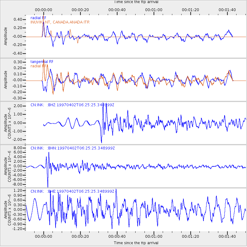
Signal To Noise
| Channel | StoN | STA | LTA |
| CN:INK: :BHN:19970402T06:25:25.348999Z | 13.216369 | 2.8343402E-6 | 2.144568E-7 |
| CN:INK: :BHE:19970402T06:25:25.348999Z | 1.0288353 | 4.1044677E-7 | 3.9894314E-7 |
| CN:INK: :BHZ:19970402T06:25:25.348999Z | 4.020655 | 1.1168546E-6 | 2.7777926E-7 |
| Arrivals |
| Ps | |
| PpPs | |
| PsPs/PpSs | |


