You are here: Home > Network List > IU - Global Seismograph Network (GSN - IRIS/USGS) Stations List
> Station RSSD Black Hills, South Dakota, USA > Earthquake Result Viewer
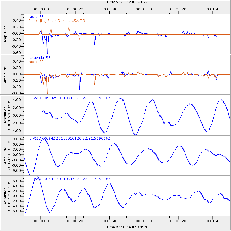
RSSD Black Hills, South Dakota, USA - Earthquake Result Viewer
*The percent match for this event was below the threshold and hence no stack was calculated.
| Earthquake location: |
Off East Coast Of Honshu, Japan |
| Earthquake latitude/longitude: |
40.2/143.2 |
| Earthquake time(UTC): |
2011/09/16 (259) 20:11:16 GMT |
| Earthquake Depth: |
35 km |
| Earthquake Magnitude: |
5.5 MB, 5.8 MW |
| Earthquake Catalog/Contributor: |
WHDF/NEIC |
|
| Network: |
IU Global Seismograph Network (GSN - IRIS/USGS) |
| Station: |
RSSD Black Hills, South Dakota, USA |
| Lat/Lon: |
44.12 N/104.04 W |
| Elevation: |
2090 m |
|
| Distance: |
76.5 deg |
| Az: |
43.091 deg |
| Baz: |
313.434 deg |
| Ray Param: |
$rayparam |
*The percent match for this event was below the threshold and hence was not used in the summary stack. |
|
| Radial Match: |
96.79599 % |
| Radial Bump: |
331 |
| Transverse Match: |
95.51485 % |
| Transverse Bump: |
210 |
| SOD ConfigId: |
558545 |
| Insert Time: |
2013-09-19 03:08:47.933 +0000 |
| GWidth: |
2.5 |
| Max Bumps: |
400 |
| Tol: |
0.001 |
|
Signal To Noise
| Channel | StoN | STA | LTA |
| IU:RSSD:00:BHZ:20110916T20:22:31.519016Z | 1.7003455 | 8.483671E-6 | 4.9893806E-6 |
| IU:RSSD:00:BH1:20110916T20:22:31.519016Z | 1.3999513 | 4.3473456E-6 | 3.1053546E-6 |
| IU:RSSD:00:BH2:20110916T20:22:31.519016Z | 3.100865 | 2.5902998E-6 | 8.353475E-7 |
| Arrivals |
| Ps | |
| PpPs | |
| PsPs/PpSs | |


