You are here: Home > Network List > II - Global Seismograph Network (GSN - IRIS/IDA) Stations List
> Station WRAB Tennant Creek, NT, Australia > Earthquake Result Viewer
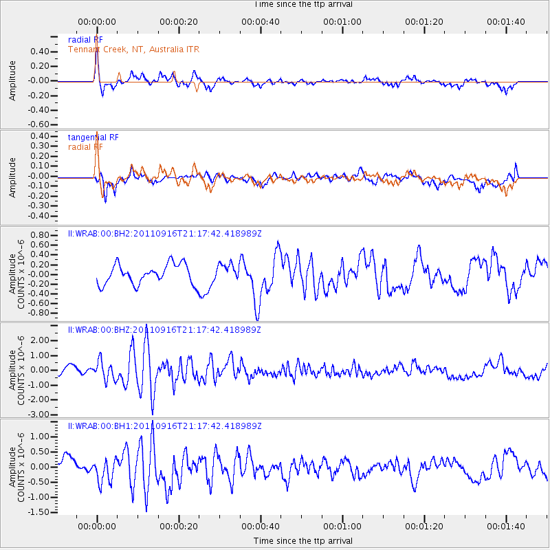
WRAB Tennant Creek, NT, Australia - Earthquake Result Viewer
*The percent match for this event was below the threshold and hence no stack was calculated.
| Earthquake location: |
Off East Coast Of Honshu, Japan |
| Earthquake latitude/longitude: |
40.2/143.0 |
| Earthquake time(UTC): |
2011/09/16 (259) 21:08:05 GMT |
| Earthquake Depth: |
18 km |
| Earthquake Magnitude: |
6.0 MW, 5.7 MB, 5.8 MS, 5.9 MW |
| Earthquake Catalog/Contributor: |
NEIC PDE/NEIC PDE-M |
|
| Network: |
II Global Seismograph Network (GSN - IRIS/IDA) |
| Station: |
WRAB Tennant Creek, NT, Australia |
| Lat/Lon: |
19.93 S/134.36 E |
| Elevation: |
366 m |
|
| Distance: |
60.4 deg |
| Az: |
189.363 deg |
| Baz: |
7.607 deg |
| Ray Param: |
$rayparam |
*The percent match for this event was below the threshold and hence was not used in the summary stack. |
|
| Radial Match: |
71.57059 % |
| Radial Bump: |
400 |
| Transverse Match: |
54.111515 % |
| Transverse Bump: |
400 |
| SOD ConfigId: |
558545 |
| Insert Time: |
2013-09-19 03:10:40.693 +0000 |
| GWidth: |
2.5 |
| Max Bumps: |
400 |
| Tol: |
0.001 |
|
Signal To Noise
| Channel | StoN | STA | LTA |
| II:WRAB:00:BHZ:20110916T21:17:42.418989Z | 2.9385443 | 6.4080973E-7 | 2.1807045E-7 |
| II:WRAB:00:BH1:20110916T21:17:42.418989Z | 1.2666916 | 3.932699E-7 | 3.104701E-7 |
| II:WRAB:00:BH2:20110916T21:17:42.418989Z | 0.8496285 | 1.7279352E-7 | 2.0337538E-7 |
| Arrivals |
| Ps | |
| PpPs | |
| PsPs/PpSs | |


