You are here: Home > Network List > US - United States National Seismic Network Stations List
> Station AGMN Agassiz National Wildlife Refuge, Minnesota, USA > Earthquake Result Viewer
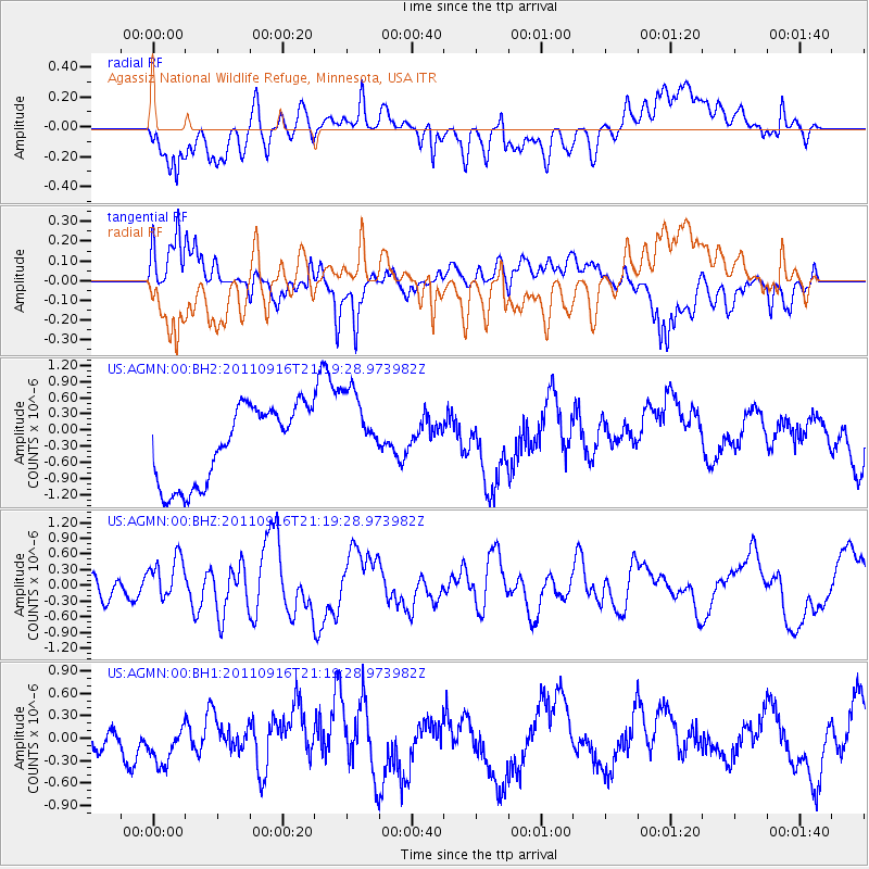
AGMN Agassiz National Wildlife Refuge, Minnesota, USA - Earthquake Result Viewer
*The percent match for this event was below the threshold and hence no stack was calculated.
| Earthquake location: |
Off East Coast Of Honshu, Japan |
| Earthquake latitude/longitude: |
40.2/143.0 |
| Earthquake time(UTC): |
2011/09/16 (259) 21:08:05 GMT |
| Earthquake Depth: |
18 km |
| Earthquake Magnitude: |
6.0 MW, 5.7 MB, 5.8 MS, 5.9 MW |
| Earthquake Catalog/Contributor: |
NEIC PDE/NEIC PDE-M |
|
| Network: |
US United States National Seismic Network |
| Station: |
AGMN Agassiz National Wildlife Refuge, Minnesota, USA |
| Lat/Lon: |
48.30 N/95.86 W |
| Elevation: |
351 m |
|
| Distance: |
77.6 deg |
| Az: |
35.82 deg |
| Baz: |
317.863 deg |
| Ray Param: |
$rayparam |
*The percent match for this event was below the threshold and hence was not used in the summary stack. |
|
| Radial Match: |
44.51642 % |
| Radial Bump: |
400 |
| Transverse Match: |
71.962555 % |
| Transverse Bump: |
400 |
| SOD ConfigId: |
558545 |
| Insert Time: |
2013-09-19 03:11:32.020 +0000 |
| GWidth: |
2.5 |
| Max Bumps: |
400 |
| Tol: |
0.001 |
|
Signal To Noise
| Channel | StoN | STA | LTA |
| US:AGMN:00:BHZ:20110916T21:19:28.973982Z | 1.8389757 | 4.187766E-7 | 2.2772275E-7 |
| US:AGMN:00:BH1:20110916T21:19:28.973982Z | 0.9918362 | 2.6645168E-7 | 2.6864484E-7 |
| US:AGMN:00:BH2:20110916T21:19:28.973982Z | 1.0779563 | 7.716071E-7 | 7.158055E-7 |
| Arrivals |
| Ps | |
| PpPs | |
| PsPs/PpSs | |


