You are here: Home > Network List > CN - Canadian National Seismograph Network Stations List
> Station INK INUVIK, NT, CANADA.ANADA > Earthquake Result Viewer
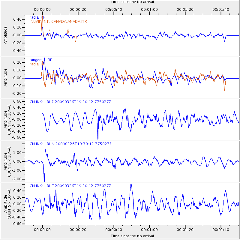
INK INUVIK, NT, CANADA.ANADA - Earthquake Result Viewer
*The percent match for this event was below the threshold and hence no stack was calculated.
| Earthquake location: |
Northwest Of Ryukyu Islands |
| Earthquake latitude/longitude: |
27.4/126.7 |
| Earthquake time(UTC): |
2009/03/26 (085) 19:19:59 GMT |
| Earthquake Depth: |
160 km |
| Earthquake Magnitude: |
5.6 MB, 5.9 MW, 5.9 MW |
| Earthquake Catalog/Contributor: |
WHDF/NEIC |
|
| Network: |
CN Canadian National Seismograph Network |
| Station: |
INK INUVIK, NT, CANADA.ANADA |
| Lat/Lon: |
68.31 N/133.52 W |
| Elevation: |
40 m |
|
| Distance: |
68.3 deg |
| Az: |
23.217 deg |
| Baz: |
289.512 deg |
| Ray Param: |
$rayparam |
*The percent match for this event was below the threshold and hence was not used in the summary stack. |
|
| Radial Match: |
44.551334 % |
| Radial Bump: |
400 |
| Transverse Match: |
58.352165 % |
| Transverse Bump: |
400 |
| SOD ConfigId: |
2658 |
| Insert Time: |
2010-02-27 06:25:40.029 +0000 |
| GWidth: |
2.5 |
| Max Bumps: |
400 |
| Tol: |
0.001 |
|
Signal To Noise
| Channel | StoN | STA | LTA |
| CN:INK: :BHN:20090326T19:30:12.775027Z | 6.9531217 | 7.9356556E-7 | 1.14130835E-7 |
| CN:INK: :BHE:20090326T19:30:12.775027Z | 0.86217165 | 1.491269E-7 | 1.7296661E-7 |
| CN:INK: :BHZ:20090326T19:30:12.775027Z | 1.4228741 | 2.549692E-7 | 1.791931E-7 |
| Arrivals |
| Ps | |
| PpPs | |
| PsPs/PpSs | |


