You are here: Home > Network List > CN - Canadian National Seismograph Network Stations List
> Station INK INUVIK, NT, CANADA.ANADA > Earthquake Result Viewer
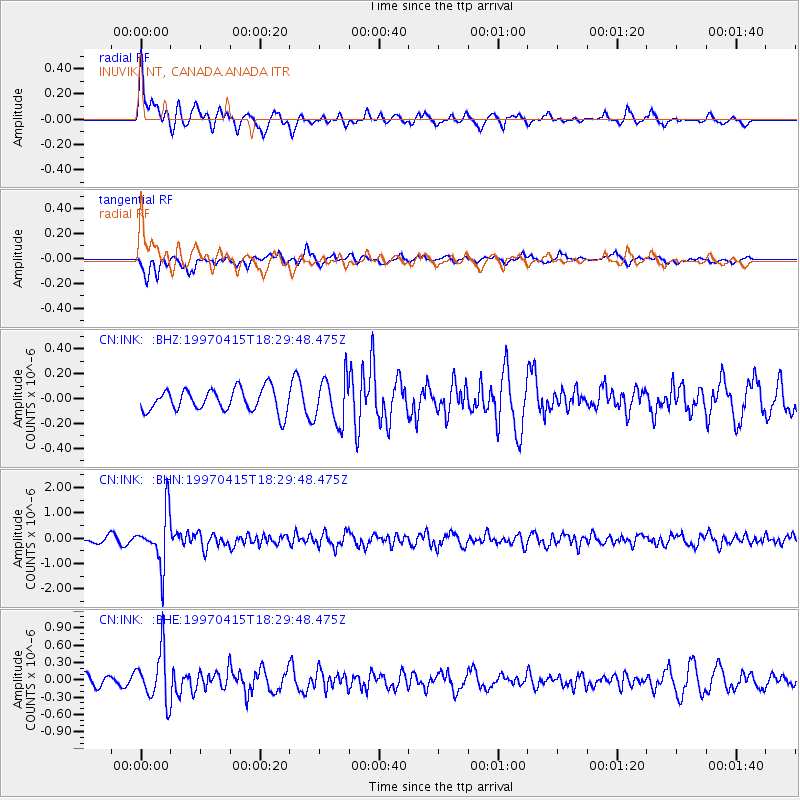
INK INUVIK, NT, CANADA.ANADA - Earthquake Result Viewer
*The percent match for this event was below the threshold and hence no stack was calculated.
| Earthquake location: |
Southern Xinjiang, China |
| Earthquake latitude/longitude: |
39.6/77.0 |
| Earthquake time(UTC): |
1997/04/15 (105) 18:19:10 GMT |
| Earthquake Depth: |
23 km |
| Earthquake Magnitude: |
5.8 MS, 5.4 MB, 5.9 UNKNOWN, 5.7 MW |
| Earthquake Catalog/Contributor: |
WHDF/NEIC |
|
| Network: |
CN Canadian National Seismograph Network |
| Station: |
INK INUVIK, NT, CANADA.ANADA |
| Lat/Lon: |
68.31 N/133.52 W |
| Elevation: |
40 m |
|
| Distance: |
70.0 deg |
| Az: |
11.59 deg |
| Baz: |
335.335 deg |
| Ray Param: |
$rayparam |
*The percent match for this event was below the threshold and hence was not used in the summary stack. |
|
| Radial Match: |
73.767365 % |
| Radial Bump: |
381 |
| Transverse Match: |
52.771706 % |
| Transverse Bump: |
351 |
| SOD ConfigId: |
4480 |
| Insert Time: |
2010-02-27 06:25:40.860 +0000 |
| GWidth: |
2.5 |
| Max Bumps: |
400 |
| Tol: |
0.001 |
|
Signal To Noise
| Channel | StoN | STA | LTA |
| CN:INK: :BHN:19970415T18:29:48.475Z | 6.344266 | 1.028729E-6 | 1.62151E-7 |
| CN:INK: :BHE:19970415T18:29:48.475Z | 6.4949374 | 4.3306665E-7 | 6.667757E-8 |
| CN:INK: :BHZ:19970415T18:29:48.475Z | 1.999805 | 1.8162707E-7 | 9.082239E-8 |
| Arrivals |
| Ps | |
| PpPs | |
| PsPs/PpSs | |


