You are here: Home > Network List > IU - Global Seismograph Network (GSN - IRIS/USGS) Stations List
> Station POHA Pohakuloa, Hawaii, USA > Earthquake Result Viewer
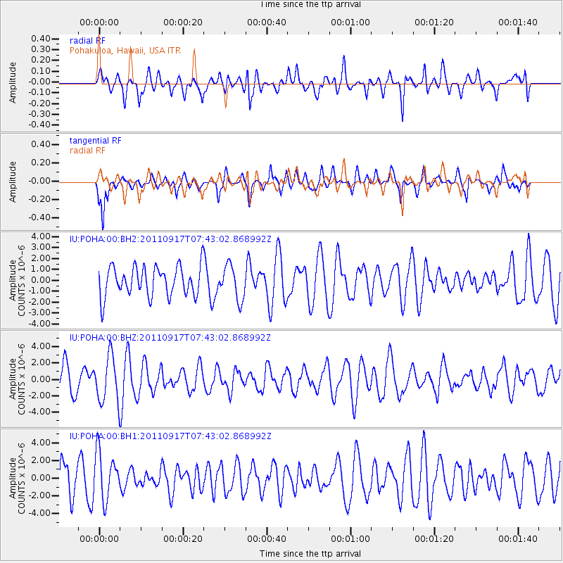
POHA Pohakuloa, Hawaii, USA - Earthquake Result Viewer
*The percent match for this event was below the threshold and hence no stack was calculated.
| Earthquake location: |
Near East Coast Of Honshu, Japan |
| Earthquake latitude/longitude: |
40.3/142.9 |
| Earthquake time(UTC): |
2011/09/17 (260) 07:33:57 GMT |
| Earthquake Depth: |
30 km |
| Earthquake Magnitude: |
5.7 MW |
| Earthquake Catalog/Contributor: |
NEIC PDE/NEIC PDE-M |
|
| Network: |
IU Global Seismograph Network (GSN - IRIS/USGS) |
| Station: |
POHA Pohakuloa, Hawaii, USA |
| Lat/Lon: |
19.76 N/155.53 W |
| Elevation: |
1990 m |
|
| Distance: |
56.0 deg |
| Az: |
92.175 deg |
| Baz: |
305.753 deg |
| Ray Param: |
$rayparam |
*The percent match for this event was below the threshold and hence was not used in the summary stack. |
|
| Radial Match: |
39.222767 % |
| Radial Bump: |
400 |
| Transverse Match: |
58.31342 % |
| Transverse Bump: |
400 |
| SOD ConfigId: |
558545 |
| Insert Time: |
2013-09-19 03:18:53.949 +0000 |
| GWidth: |
2.5 |
| Max Bumps: |
400 |
| Tol: |
0.001 |
|
Signal To Noise
| Channel | StoN | STA | LTA |
| IU:POHA:00:BHZ:20110917T07:43:02.868992Z | 1.9033539 | 2.9312573E-6 | 1.5400485E-6 |
| IU:POHA:00:BH1:20110917T07:43:02.868992Z | 1.2325357 | 2.7232993E-6 | 2.2095094E-6 |
| IU:POHA:00:BH2:20110917T07:43:02.868992Z | 1.1934932 | 1.6096998E-6 | 1.3487297E-6 |
| Arrivals |
| Ps | |
| PpPs | |
| PsPs/PpSs | |


