You are here: Home > Network List > CN - Canadian National Seismograph Network Stations List
> Station INK INUVIK, NT, CANADA.ANADA > Earthquake Result Viewer
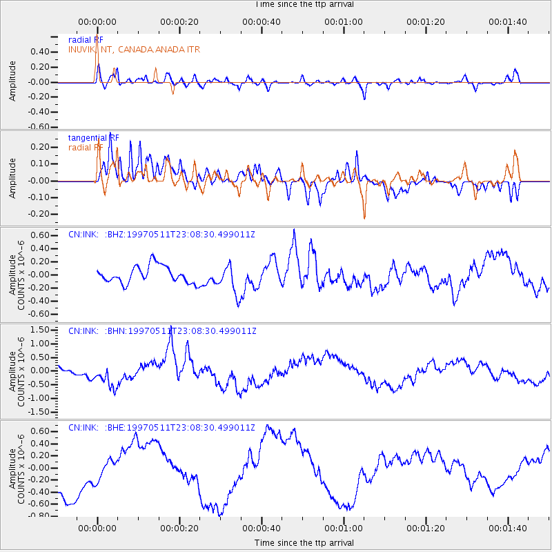
INK INUVIK, NT, CANADA.ANADA - Earthquake Result Viewer
*The percent match for this event was below the threshold and hence no stack was calculated.
| Earthquake location: |
Eastern Honshu, Japan |
| Earthquake latitude/longitude: |
37.1/140.9 |
| Earthquake time(UTC): |
1997/05/11 (131) 22:59:38 GMT |
| Earthquake Depth: |
49 km |
| Earthquake Magnitude: |
5.5 MB, 5.3 MS |
| Earthquake Catalog/Contributor: |
WHDF/NEIC |
|
| Network: |
CN Canadian National Seismograph Network |
| Station: |
INK INUVIK, NT, CANADA.ANADA |
| Lat/Lon: |
68.31 N/133.52 W |
| Elevation: |
40 m |
|
| Distance: |
54.5 deg |
| Az: |
27.078 deg |
| Baz: |
281.753 deg |
| Ray Param: |
$rayparam |
*The percent match for this event was below the threshold and hence was not used in the summary stack. |
|
| Radial Match: |
64.754684 % |
| Radial Bump: |
400 |
| Transverse Match: |
76.7008 % |
| Transverse Bump: |
366 |
| SOD ConfigId: |
4480 |
| Insert Time: |
2010-02-27 06:25:51.819 +0000 |
| GWidth: |
2.5 |
| Max Bumps: |
400 |
| Tol: |
0.001 |
|
Signal To Noise
| Channel | StoN | STA | LTA |
| CN:INK: :BHN:19970511T23:08:30.499011Z | 2.2903996 | 4.5251574E-7 | 1.9757067E-7 |
| CN:INK: :BHE:19970511T23:08:30.499011Z | 0.49996772 | 1.6833802E-7 | 3.3669778E-7 |
| CN:INK: :BHZ:19970511T23:08:30.499011Z | 1.7652458 | 2.2818078E-7 | 1.292629E-7 |
| Arrivals |
| Ps | |
| PpPs | |
| PsPs/PpSs | |


