You are here: Home > Network List > IU - Global Seismograph Network (GSN - IRIS/USGS) Stations List
> Station KEV Kevo, Finland > Earthquake Result Viewer
KEV Kevo, Finland - Earthquake Result Viewer
| Earthquake location: |
Sikkim, India |
| Earthquake latitude/longitude: |
27.7/88.2 |
| Earthquake time(UTC): |
2011/09/18 (261) 12:40:51 GMT |
| Earthquake Depth: |
50 km |
| Earthquake Magnitude: |
6.6 MB, 6.7 MS, 6.9 MW, 6.9 MW |
| Earthquake Catalog/Contributor: |
WHDF/NEIC |
|
| Network: |
IU Global Seismograph Network (GSN - IRIS/USGS) |
| Station: |
KEV Kevo, Finland |
| Lat/Lon: |
69.76 N/27.00 E |
| Elevation: |
100 m |
|
| Distance: |
54.4 deg |
| Az: |
337.966 deg |
| Baz: |
107.167 deg |
| Ray Param: |
0.0653848 |
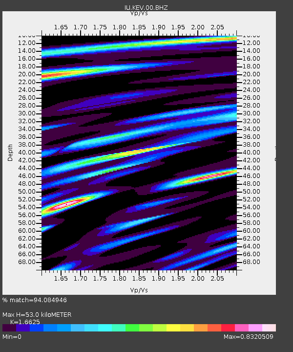
| Estimated Moho Depth: |
53.0 km |
| Estimated Crust Vp/Vs: |
1.66 |
| Assumed Crust Vp: |
6.622 km/s |
| Estimated Crust Vs: |
3.983 km/s |
| Estimated Crust Poisson's Ratio: |
0.22 |
|
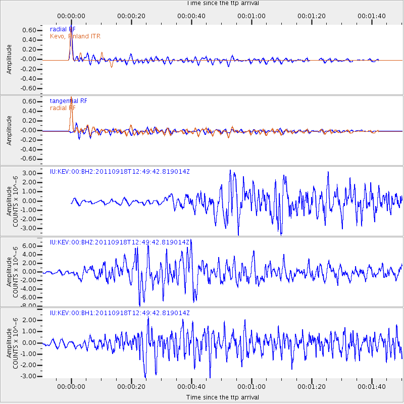
| Radial Match: |
94.084946 % |
| Radial Bump: |
369 |
| Transverse Match: |
91.256355 % |
| Transverse Bump: |
400 |
| SOD ConfigId: |
558545 |
| Insert Time: |
2013-09-19 03:23:22.424 +0000 |
| GWidth: |
2.5 |
| Max Bumps: |
400 |
| Tol: |
0.001 |
|
Signal To Noise
| Channel | StoN | STA | LTA |
| IU:KEV:00:BHZ:20110918T12:49:42.819014Z | 4.2492595 | 9.187646E-7 | 2.162176E-7 |
| IU:KEV:00:BH1:20110918T12:49:42.819014Z | 1.3335662 | 2.1570425E-7 | 1.6174994E-7 |
| IU:KEV:00:BH2:20110918T12:49:42.819014Z | 2.6481392 | 5.1054604E-7 | 1.9279426E-7 |
| Arrivals |
| Ps | 5.6 SECOND |
| PpPs | 20 SECOND |
| PsPs/PpSs | 26 SECOND |


