You are here: Home > Network List > CN - Canadian National Seismograph Network Stations List
> Station INK INUVIK, NT, CANADA.ANADA > Earthquake Result Viewer
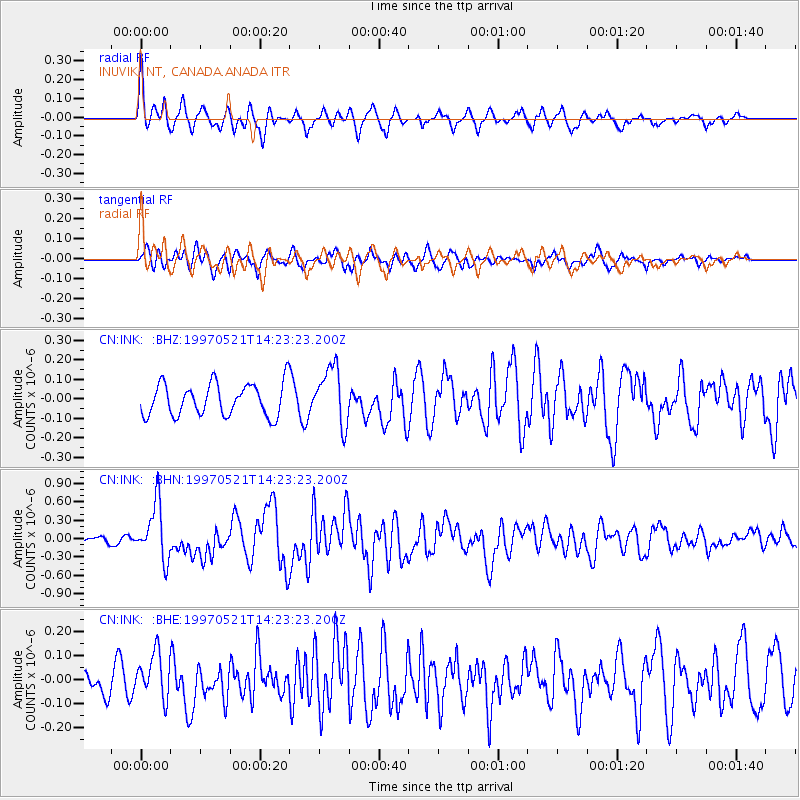
INK INUVIK, NT, CANADA.ANADA - Earthquake Result Viewer
*The percent match for this event was below the threshold and hence no stack was calculated.
| Earthquake location: |
Vanuatu Islands |
| Earthquake latitude/longitude: |
-20.4/169.3 |
| Earthquake time(UTC): |
1997/05/21 (141) 14:10:26 GMT |
| Earthquake Depth: |
57 km |
| Earthquake Magnitude: |
5.9 MB, 6.5 MS, 6.7 UNKNOWN, 6.1 ME |
| Earthquake Catalog/Contributor: |
WHDF/NEIC |
|
| Network: |
CN Canadian National Seismograph Network |
| Station: |
INK INUVIK, NT, CANADA.ANADA |
| Lat/Lon: |
68.31 N/133.52 W |
| Elevation: |
40 m |
|
| Distance: |
97.7 deg |
| Az: |
18.379 deg |
| Baz: |
232.687 deg |
| Ray Param: |
$rayparam |
*The percent match for this event was below the threshold and hence was not used in the summary stack. |
|
| Radial Match: |
68.64018 % |
| Radial Bump: |
385 |
| Transverse Match: |
56.12387 % |
| Transverse Bump: |
400 |
| SOD ConfigId: |
4480 |
| Insert Time: |
2010-02-27 06:26:01.239 +0000 |
| GWidth: |
2.5 |
| Max Bumps: |
400 |
| Tol: |
0.001 |
|
Signal To Noise
| Channel | StoN | STA | LTA |
| CN:INK: :BHN:19970521T14:23:23.200Z | 5.439461 | 4.5904824E-7 | 8.439223E-8 |
| CN:INK: :BHE:19970521T14:23:23.200Z | 1.5630382 | 9.320491E-8 | 5.96306E-8 |
| CN:INK: :BHZ:19970521T14:23:23.200Z | 1.7923505 | 1.4751662E-7 | 8.2303444E-8 |
| Arrivals |
| Ps | |
| PpPs | |
| PsPs/PpSs | |


