You are here: Home > Network List > US - United States National Seismic Network Stations List
> Station BLA Blacksburg, Virginia, USA > Earthquake Result Viewer
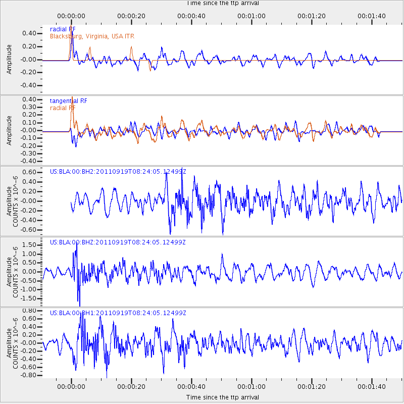
BLA Blacksburg, Virginia, USA - Earthquake Result Viewer
*The percent match for this event was below the threshold and hence no stack was calculated.
| Earthquake location: |
Fox Islands, Aleutian Islands |
| Earthquake latitude/longitude: |
52.0/-172.0 |
| Earthquake time(UTC): |
2011/09/19 (262) 08:14:14 GMT |
| Earthquake Depth: |
31 km |
| Earthquake Magnitude: |
5.5 MB, 5.1 MS, 5.7 MW, 5.6 MW |
| Earthquake Catalog/Contributor: |
WHDF/NEIC |
|
| Network: |
US United States National Seismic Network |
| Station: |
BLA Blacksburg, Virginia, USA |
| Lat/Lon: |
37.21 N/80.42 W |
| Elevation: |
634 m |
|
| Distance: |
62.6 deg |
| Az: |
64.009 deg |
| Baz: |
315.934 deg |
| Ray Param: |
$rayparam |
*The percent match for this event was below the threshold and hence was not used in the summary stack. |
|
| Radial Match: |
54.279274 % |
| Radial Bump: |
400 |
| Transverse Match: |
55.493736 % |
| Transverse Bump: |
400 |
| SOD ConfigId: |
558545 |
| Insert Time: |
2013-09-19 03:26:01.651 +0000 |
| GWidth: |
2.5 |
| Max Bumps: |
400 |
| Tol: |
0.001 |
|
Signal To Noise
| Channel | StoN | STA | LTA |
| US:BLA:00:BHZ:20110919T08:24:05.12499Z | 4.1883307 | 7.33824E-7 | 1.752068E-7 |
| US:BLA:00:BH1:20110919T08:24:05.12499Z | 2.526345 | 3.83333E-7 | 1.5173423E-7 |
| US:BLA:00:BH2:20110919T08:24:05.12499Z | 2.0048156 | 3.055814E-7 | 1.5242371E-7 |
| Arrivals |
| Ps | |
| PpPs | |
| PsPs/PpSs | |


