You are here: Home > Network List > US - United States National Seismic Network Stations List
> Station DGMT Dagmar, Montana, USA > Earthquake Result Viewer
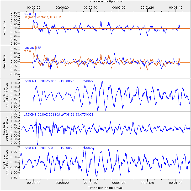
DGMT Dagmar, Montana, USA - Earthquake Result Viewer
*The percent match for this event was below the threshold and hence no stack was calculated.
| Earthquake location: |
Fox Islands, Aleutian Islands |
| Earthquake latitude/longitude: |
52.0/-172.0 |
| Earthquake time(UTC): |
2011/09/19 (262) 08:14:14 GMT |
| Earthquake Depth: |
31 km |
| Earthquake Magnitude: |
5.5 MB, 5.1 MS, 5.7 MW, 5.6 MW |
| Earthquake Catalog/Contributor: |
WHDF/NEIC |
|
| Network: |
US United States National Seismic Network |
| Station: |
DGMT Dagmar, Montana, USA |
| Lat/Lon: |
48.47 N/104.20 W |
| Elevation: |
0.0 m |
|
| Distance: |
42.1 deg |
| Az: |
66.867 deg |
| Baz: |
301.398 deg |
| Ray Param: |
$rayparam |
*The percent match for this event was below the threshold and hence was not used in the summary stack. |
|
| Radial Match: |
47.45952 % |
| Radial Bump: |
378 |
| Transverse Match: |
38.82295 % |
| Transverse Bump: |
330 |
| SOD ConfigId: |
558545 |
| Insert Time: |
2013-09-19 03:26:21.737 +0000 |
| GWidth: |
2.5 |
| Max Bumps: |
400 |
| Tol: |
0.001 |
|
Signal To Noise
| Channel | StoN | STA | LTA |
| US:DGMT:00:BHZ:20110919T08:21:33.075002Z | 3.8535795 | 9.2544144E-7 | 2.4015114E-7 |
| US:DGMT:00:BH1:20110919T08:21:33.075002Z | 0.63787323 | 3.215692E-7 | 5.041271E-7 |
| US:DGMT:00:BH2:20110919T08:21:33.075002Z | 1.8217437 | 8.3544035E-7 | 4.585938E-7 |
| Arrivals |
| Ps | |
| PpPs | |
| PsPs/PpSs | |


