You are here: Home > Network List > CN - Canadian National Seismograph Network Stations List
> Station INK INUVIK, NT, CANADA.ANADA > Earthquake Result Viewer
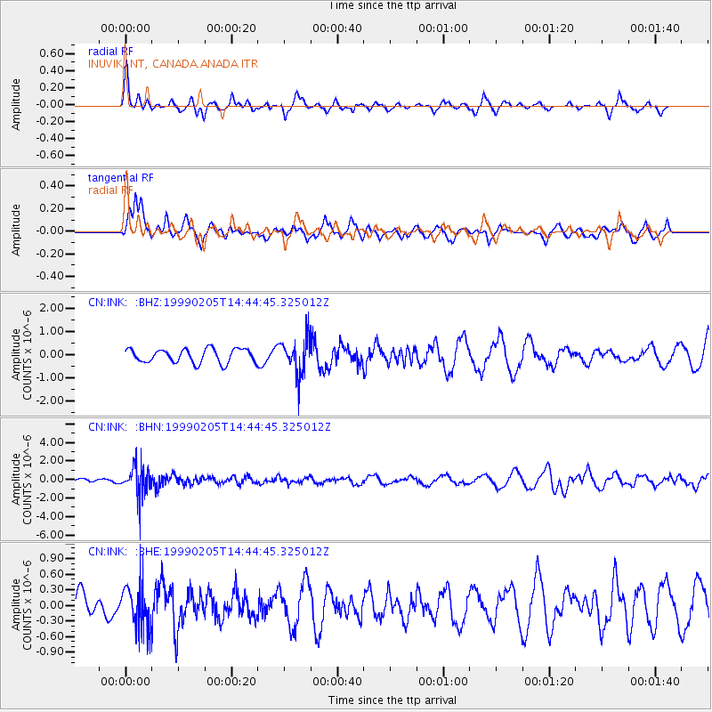
INK INUVIK, NT, CANADA.ANADA - Earthquake Result Viewer
*The percent match for this event was below the threshold and hence no stack was calculated.
| Earthquake location: |
Northwest Of Kuril Islands |
| Earthquake latitude/longitude: |
47.5/147.2 |
| Earthquake time(UTC): |
1999/02/05 (036) 14:37:53 GMT |
| Earthquake Depth: |
407 km |
| Earthquake Magnitude: |
6.0 MW, 5.4 MB, 5.8 MW |
| Earthquake Catalog/Contributor: |
WHDF/NEIC |
|
| Network: |
CN Canadian National Seismograph Network |
| Station: |
INK INUVIK, NT, CANADA.ANADA |
| Lat/Lon: |
68.31 N/133.52 W |
| Elevation: |
40 m |
|
| Distance: |
43.2 deg |
| Az: |
32.263 deg |
| Baz: |
283.233 deg |
| Ray Param: |
$rayparam |
*The percent match for this event was below the threshold and hence was not used in the summary stack. |
|
| Radial Match: |
48.375034 % |
| Radial Bump: |
325 |
| Transverse Match: |
63.597507 % |
| Transverse Bump: |
400 |
| SOD ConfigId: |
4480 |
| Insert Time: |
2010-02-27 06:26:09.347 +0000 |
| GWidth: |
2.5 |
| Max Bumps: |
400 |
| Tol: |
0.001 |
|
Signal To Noise
| Channel | StoN | STA | LTA |
| CN:INK: :BHN:19990205T14:44:45.325012Z | 4.115397 | 1.6057243E-6 | 3.9017482E-7 |
| CN:INK: :BHE:19990205T14:44:45.325012Z | 1.7360911 | 4.138039E-7 | 2.3835379E-7 |
| CN:INK: :BHZ:19990205T14:44:45.325012Z | 2.5523696 | 7.566692E-7 | 2.9645753E-7 |
| Arrivals |
| Ps | |
| PpPs | |
| PsPs/PpSs | |


