You are here: Home > Network List > CN - Canadian National Seismograph Network Stations List
> Station INK INUVIK, NT, CANADA.ANADA > Earthquake Result Viewer
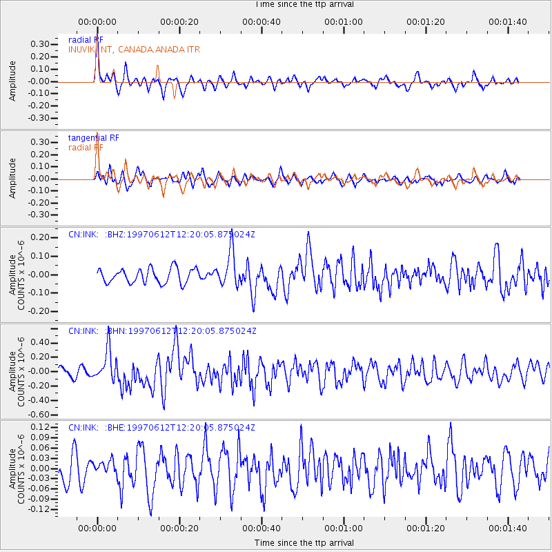
INK INUVIK, NT, CANADA.ANADA - Earthquake Result Viewer
*The percent match for this event was below the threshold and hence no stack was calculated.
| Earthquake location: |
Eastern New Guinea Reg., P.N.G. |
| Earthquake latitude/longitude: |
-6.0/147.0 |
| Earthquake time(UTC): |
1997/06/12 (163) 12:07:33 GMT |
| Earthquake Depth: |
33 km |
| Earthquake Magnitude: |
5.7 MB, 5.9 MS, 6.0 UNKNOWN |
| Earthquake Catalog/Contributor: |
WHDF/NEIC |
|
| Network: |
CN Canadian National Seismograph Network |
| Station: |
INK INUVIK, NT, CANADA.ANADA |
| Lat/Lon: |
68.31 N/133.52 W |
| Elevation: |
40 m |
|
| Distance: |
91.6 deg |
| Az: |
21.447 deg |
| Baz: |
258.032 deg |
| Ray Param: |
$rayparam |
*The percent match for this event was below the threshold and hence was not used in the summary stack. |
|
| Radial Match: |
72.44442 % |
| Radial Bump: |
385 |
| Transverse Match: |
66.31453 % |
| Transverse Bump: |
400 |
| SOD ConfigId: |
4480 |
| Insert Time: |
2010-02-27 06:26:16.812 +0000 |
| GWidth: |
2.5 |
| Max Bumps: |
400 |
| Tol: |
0.001 |
|
Signal To Noise
| Channel | StoN | STA | LTA |
| CN:INK: :BHN:19970612T12:20:05.875024Z | 3.7830904 | 2.3097512E-7 | 6.1054614E-8 |
| CN:INK: :BHE:19970612T12:20:05.875024Z | 0.658321 | 1.9053733E-8 | 2.894292E-8 |
| CN:INK: :BHZ:19970612T12:20:05.875024Z | 2.4839215 | 9.7929146E-8 | 3.942522E-8 |
| Arrivals |
| Ps | |
| PpPs | |
| PsPs/PpSs | |


