You are here: Home > Network List > US - United States National Seismic Network Stations List
> Station MSO Missoula, Montana, USA > Earthquake Result Viewer
MSO Missoula, Montana, USA - Earthquake Result Viewer
*The percent match for this event was below the threshold and hence no stack was calculated.
| Earthquake location: |
Guatemala |
| Earthquake latitude/longitude: |
14.2/-90.2 |
| Earthquake time(UTC): |
2011/09/19 (262) 18:33:55 GMT |
| Earthquake Depth: |
9.0 km |
| Earthquake Magnitude: |
5.6 MW, 5.3 MS, 5.1 MB, 5.6 MW |
| Earthquake Catalog/Contributor: |
WHDF/NEIC |
|
| Network: |
US United States National Seismic Network |
| Station: |
MSO Missoula, Montana, USA |
| Lat/Lon: |
46.83 N/113.94 W |
| Elevation: |
1264 m |
|
| Distance: |
38.1 deg |
| Az: |
333.435 deg |
| Baz: |
140.823 deg |
| Ray Param: |
$rayparam |
*The percent match for this event was below the threshold and hence was not used in the summary stack. |
|
| Radial Match: |
63.490963 % |
| Radial Bump: |
400 |
| Transverse Match: |
31.604597 % |
| Transverse Bump: |
400 |
| SOD ConfigId: |
558545 |
| Insert Time: |
2013-09-19 03:29:19.547 +0000 |
| GWidth: |
2.5 |
| Max Bumps: |
400 |
| Tol: |
0.001 |
|
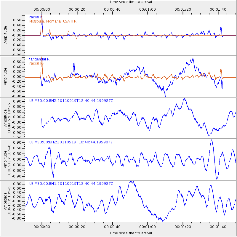
Signal To Noise
| Channel | StoN | STA | LTA |
| US:MSO:00:BHZ:20110919T18:40:44.199987Z | 2.1259625 | 3.9494935E-7 | 1.8577437E-7 |
| US:MSO:00:BH1:20110919T18:40:44.199987Z | 1.1117595 | 2.0692599E-7 | 1.8612478E-7 |
| US:MSO:00:BH2:20110919T18:40:44.199987Z | 1.7488298 | 3.1665988E-7 | 1.8106957E-7 |
| Arrivals |
| Ps | |
| PpPs | |
| PsPs/PpSs | |


