You are here: Home > Network List > IU - Global Seismograph Network (GSN - IRIS/USGS) Stations List
> Station HNR Honiara, Solomon Islands > Earthquake Result Viewer
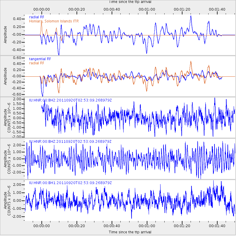
HNR Honiara, Solomon Islands - Earthquake Result Viewer
*The percent match for this event was below the threshold and hence no stack was calculated.
| Earthquake location: |
Central East Pacific Rise |
| Earthquake latitude/longitude: |
-4.5/-105.2 |
| Earthquake time(UTC): |
2011/09/20 (263) 02:40:22 GMT |
| Earthquake Depth: |
10 km |
| Earthquake Magnitude: |
5.7 MW |
| Earthquake Catalog/Contributor: |
NEIC PDE/NEIC PDE-M |
|
| Network: |
IU Global Seismograph Network (GSN - IRIS/USGS) |
| Station: |
HNR Honiara, Solomon Islands |
| Lat/Lon: |
9.44 S/159.95 E |
| Elevation: |
100 m |
|
| Distance: |
94.0 deg |
| Az: |
260.248 deg |
| Baz: |
95.243 deg |
| Ray Param: |
$rayparam |
*The percent match for this event was below the threshold and hence was not used in the summary stack. |
|
| Radial Match: |
38.79438 % |
| Radial Bump: |
400 |
| Transverse Match: |
35.502453 % |
| Transverse Bump: |
400 |
| SOD ConfigId: |
558545 |
| Insert Time: |
2013-09-19 03:30:16.963 +0000 |
| GWidth: |
2.5 |
| Max Bumps: |
400 |
| Tol: |
0.001 |
|
Signal To Noise
| Channel | StoN | STA | LTA |
| IU:HNR:00:BHZ:20110920T02:53:09.268979Z | 0.8307433 | 9.762834E-7 | 1.1751927E-6 |
| IU:HNR:00:BH1:20110920T02:53:09.268979Z | 1.3220716 | 9.334425E-7 | 7.0604534E-7 |
| IU:HNR:00:BH2:20110920T02:53:09.268979Z | 1.2344353 | 8.7312753E-7 | 7.0730925E-7 |
| Arrivals |
| Ps | |
| PpPs | |
| PsPs/PpSs | |


