You are here: Home > Network List > CN - Canadian National Seismograph Network Stations List
> Station INK INUVIK, NT, CANADA.ANADA > Earthquake Result Viewer
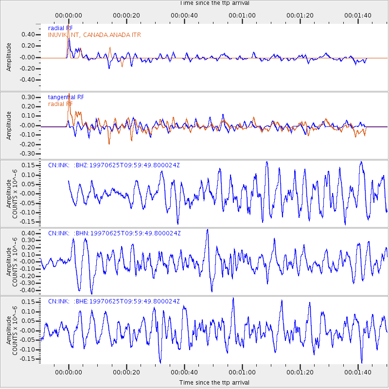
INK INUVIK, NT, CANADA.ANADA - Earthquake Result Viewer
*The percent match for this event was below the threshold and hence no stack was calculated.
| Earthquake location: |
Western Honshu, Japan |
| Earthquake latitude/longitude: |
34.4/131.6 |
| Earthquake time(UTC): |
1997/06/25 (176) 09:50:12 GMT |
| Earthquake Depth: |
10 km |
| Earthquake Magnitude: |
5.5 MB, 5.6 MS, 5.9 UNKNOWN, 5.8 MW |
| Earthquake Catalog/Contributor: |
WHDF/NEIC |
|
| Network: |
CN Canadian National Seismograph Network |
| Station: |
INK INUVIK, NT, CANADA.ANADA |
| Lat/Lon: |
68.31 N/133.52 W |
| Elevation: |
40 m |
|
| Distance: |
60.3 deg |
| Az: |
25.251 deg |
| Baz: |
288.415 deg |
| Ray Param: |
$rayparam |
*The percent match for this event was below the threshold and hence was not used in the summary stack. |
|
| Radial Match: |
76.628494 % |
| Radial Bump: |
400 |
| Transverse Match: |
66.27927 % |
| Transverse Bump: |
400 |
| SOD ConfigId: |
4480 |
| Insert Time: |
2010-02-27 06:26:25.064 +0000 |
| GWidth: |
2.5 |
| Max Bumps: |
400 |
| Tol: |
0.001 |
|
Signal To Noise
| Channel | StoN | STA | LTA |
| CN:INK: :BHN:19970625T09:59:49.800024Z | 4.1266346 | 2.1014027E-7 | 5.0922917E-8 |
| CN:INK: :BHE:19970625T09:59:49.800024Z | 1.6251887 | 5.5236256E-8 | 3.3987593E-8 |
| CN:INK: :BHZ:19970625T09:59:49.800024Z | 2.0291607 | 6.717096E-8 | 3.310283E-8 |
| Arrivals |
| Ps | |
| PpPs | |
| PsPs/PpSs | |


