You are here: Home > Network List > CN - Canadian National Seismograph Network Stations List
> Station INK INUVIK, NT, CANADA.ANADA > Earthquake Result Viewer
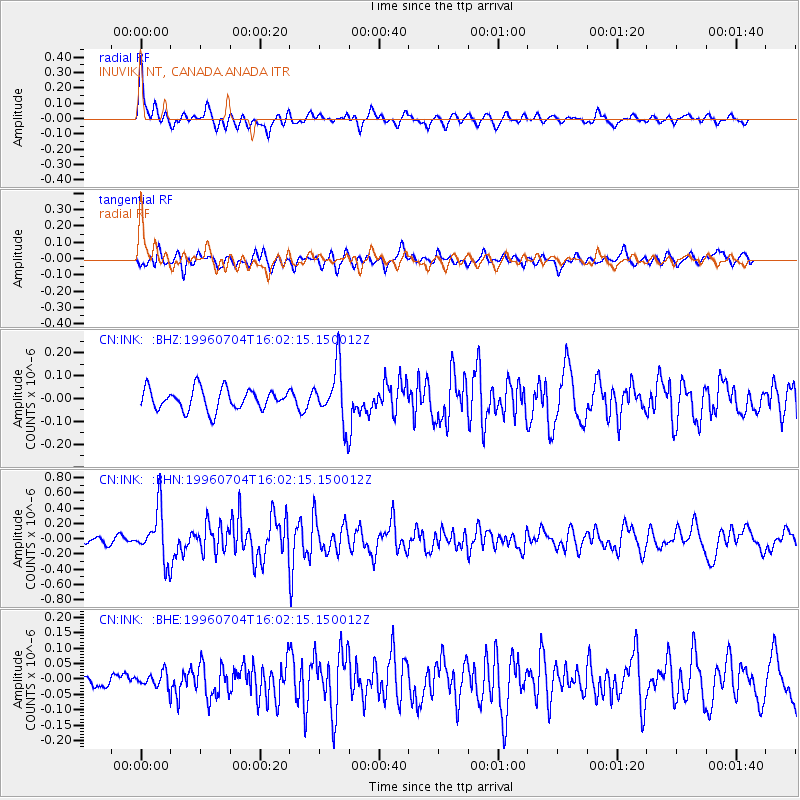
INK INUVIK, NT, CANADA.ANADA - Earthquake Result Viewer
*The percent match for this event was below the threshold and hence no stack was calculated.
| Earthquake location: |
W. Caroline Islands, Micronesia |
| Earthquake latitude/longitude: |
8.5/141.6 |
| Earthquake time(UTC): |
1996/07/04 (186) 15:50:38 GMT |
| Earthquake Depth: |
33 km |
| Earthquake Magnitude: |
5.1 MB, 5.4 MS, 6.0 UNKNOWN, 5.9 MW |
| Earthquake Catalog/Contributor: |
WHDF/NEIC |
|
| Network: |
CN Canadian National Seismograph Network |
| Station: |
INK INUVIK, NT, CANADA.ANADA |
| Lat/Lon: |
68.31 N/133.52 W |
| Elevation: |
40 m |
|
| Distance: |
80.3 deg |
| Az: |
22.068 deg |
| Baz: |
268.439 deg |
| Ray Param: |
$rayparam |
*The percent match for this event was below the threshold and hence was not used in the summary stack. |
|
| Radial Match: |
79.813934 % |
| Radial Bump: |
400 |
| Transverse Match: |
70.40348 % |
| Transverse Bump: |
400 |
| SOD ConfigId: |
4480 |
| Insert Time: |
2010-02-27 06:26:29.461 +0000 |
| GWidth: |
2.5 |
| Max Bumps: |
400 |
| Tol: |
0.001 |
|
Signal To Noise
| Channel | StoN | STA | LTA |
| CN:INK: :BHN:19960704T16:02:15.150012Z | 5.576472 | 3.280932E-7 | 5.8835266E-8 |
| CN:INK: :BHE:19960704T16:02:15.150012Z | 0.5941352 | 2.3739101E-8 | 3.9955722E-8 |
| CN:INK: :BHZ:19960704T16:02:15.150012Z | 2.6712348 | 1.222507E-7 | 4.5765614E-8 |
| Arrivals |
| Ps | |
| PpPs | |
| PsPs/PpSs | |


