You are here: Home > Network List > IU - Global Seismograph Network (GSN - IRIS/USGS) Stations List
> Station PMG Port Moresby, New Guinea > Earthquake Result Viewer
PMG Port Moresby, New Guinea - Earthquake Result Viewer
| Earthquake location: |
Tonga Islands |
| Earthquake latitude/longitude: |
-15.4/-175.3 |
| Earthquake time(UTC): |
2011/09/22 (265) 23:07:03 GMT |
| Earthquake Depth: |
10 km |
| Earthquake Magnitude: |
6.4 MW, 5.9 MB, 6.3 MS, 6.3 MW |
| Earthquake Catalog/Contributor: |
NEIC PDE/NEIC PDE-M |
|
| Network: |
IU Global Seismograph Network (GSN - IRIS/USGS) |
| Station: |
PMG Port Moresby, New Guinea |
| Lat/Lon: |
9.40 S/147.16 E |
| Elevation: |
90 m |
|
| Distance: |
37.1 deg |
| Az: |
274.796 deg |
| Baz: |
103.114 deg |
| Ray Param: |
0.07632039 |
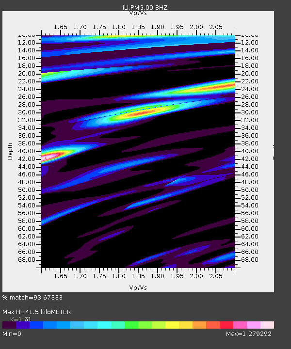
| Estimated Moho Depth: |
41.5 km |
| Estimated Crust Vp/Vs: |
1.61 |
| Assumed Crust Vp: |
6.122 km/s |
| Estimated Crust Vs: |
3.802 km/s |
| Estimated Crust Poisson's Ratio: |
0.19 |
|
| Radial Match: |
93.67333 % |
| Radial Bump: |
400 |
| Transverse Match: |
85.58165 % |
| Transverse Bump: |
400 |
| SOD ConfigId: |
558545 |
| Insert Time: |
2013-09-19 03:35:55.149 +0000 |
| GWidth: |
2.5 |
| Max Bumps: |
400 |
| Tol: |
0.001 |
|
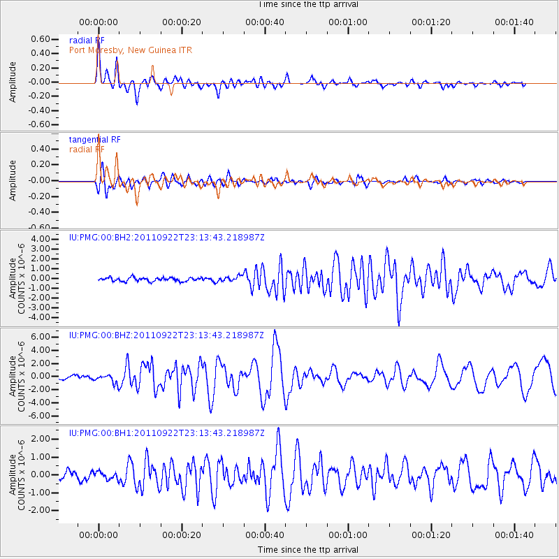
Signal To Noise
| Channel | StoN | STA | LTA |
| IU:PMG:00:BHZ:20110922T23:13:43.218987Z | 2.9420044 | 7.2459613E-7 | 2.4629335E-7 |
| IU:PMG:00:BH1:20110922T23:13:43.218987Z | 1.1431298 | 2.1031045E-7 | 1.8397773E-7 |
| IU:PMG:00:BH2:20110922T23:13:43.218987Z | 1.4458599 | 2.6533868E-7 | 1.8351616E-7 |
| Arrivals |
| Ps | 4.5 SECOND |
| PpPs | 16 SECOND |
| PsPs/PpSs | 21 SECOND |


