You are here: Home > Network List > US - United States National Seismic Network Stations List
> Station AMTX Amarillo, Texas, USA > Earthquake Result Viewer
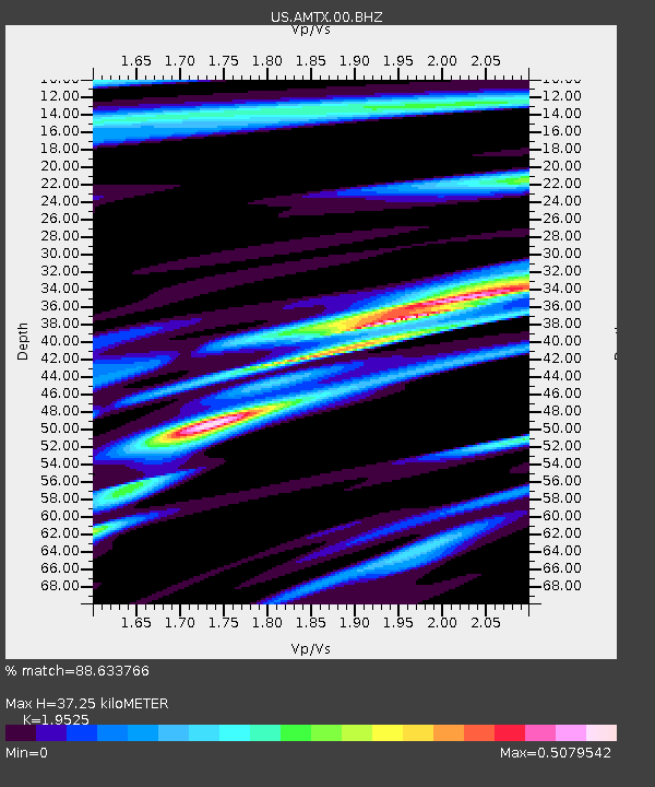
AMTX Amarillo, Texas, USA - Earthquake Result Viewer
| Earthquake location: |
Tonga Islands |
| Earthquake latitude/longitude: |
-15.4/-175.3 |
| Earthquake time(UTC): |
2011/09/22 (265) 23:07:03 GMT |
| Earthquake Depth: |
10 km |
| Earthquake Magnitude: |
6.4 MW, 5.9 MB, 6.3 MS, 6.3 MW |
| Earthquake Catalog/Contributor: |
NEIC PDE/NEIC PDE-M |
|
| Network: |
US United States National Seismic Network |
| Station: |
AMTX Amarillo, Texas, USA |
| Lat/Lon: |
34.53 N/101.41 W |
| Elevation: |
1010 m |
|
| Distance: |
85.9 deg |
| Az: |
52.68 deg |
| Baz: |
248.271 deg |
| Ray Param: |
0.044433974 |
| Estimated Moho Depth: |
37.25 km |
| Estimated Crust Vp/Vs: |
1.95 |
| Assumed Crust Vp: |
6.426 km/s |
| Estimated Crust Vs: |
3.291 km/s |
| Estimated Crust Poisson's Ratio: |
0.32 |
|
| Radial Match: |
88.633766 % |
| Radial Bump: |
322 |
| Transverse Match: |
61.627304 % |
| Transverse Bump: |
400 |
| SOD ConfigId: |
558545 |
| Insert Time: |
2013-09-19 03:36:19.306 +0000 |
| GWidth: |
2.5 |
| Max Bumps: |
400 |
| Tol: |
0.001 |
|

Signal To Noise
| Channel | StoN | STA | LTA |
| US:AMTX:00:BHZ:20110922T23:19:11.650017Z | 3.0641913 | 3.178793E-7 | 1.0374003E-7 |
| US:AMTX:00:BH1:20110922T23:19:11.650017Z | 1.4296532 | 1.4554048E-7 | 1.01801255E-7 |
| US:AMTX:00:BH2:20110922T23:19:11.650017Z | 0.96742034 | 1.1972537E-7 | 1.2375735E-7 |
| Arrivals |
| Ps | 5.6 SECOND |
| PpPs | 17 SECOND |
| PsPs/PpSs | 22 SECOND |


