You are here: Home > Network List > US - United States National Seismic Network Stations List
> Station SDCO Great Sand Dunes National Park, Colorado, USA > Earthquake Result Viewer
SDCO Great Sand Dunes National Park, Colorado, USA - Earthquake Result Viewer
| Earthquake location: |
Tonga Islands |
| Earthquake latitude/longitude: |
-15.4/-175.3 |
| Earthquake time(UTC): |
2011/09/22 (265) 23:07:03 GMT |
| Earthquake Depth: |
10 km |
| Earthquake Magnitude: |
6.4 MW, 5.9 MB, 6.3 MS, 6.3 MW |
| Earthquake Catalog/Contributor: |
NEIC PDE/NEIC PDE-M |
|
| Network: |
US United States National Seismic Network |
| Station: |
SDCO Great Sand Dunes National Park, Colorado, USA |
| Lat/Lon: |
37.75 N/105.50 W |
| Elevation: |
2569 m |
|
| Distance: |
84.1 deg |
| Az: |
48.414 deg |
| Baz: |
245.495 deg |
| Ray Param: |
0.045711868 |
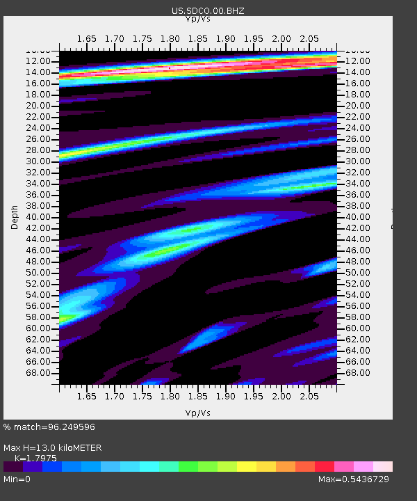
| Estimated Moho Depth: |
13.0 km |
| Estimated Crust Vp/Vs: |
1.80 |
| Assumed Crust Vp: |
6.316 km/s |
| Estimated Crust Vs: |
3.514 km/s |
| Estimated Crust Poisson's Ratio: |
0.28 |
|
| Radial Match: |
96.249596 % |
| Radial Bump: |
346 |
| Transverse Match: |
84.25131 % |
| Transverse Bump: |
400 |
| SOD ConfigId: |
558545 |
| Insert Time: |
2013-09-19 03:37:14.462 +0000 |
| GWidth: |
2.5 |
| Max Bumps: |
400 |
| Tol: |
0.001 |
|

Signal To Noise
| Channel | StoN | STA | LTA |
| US:SDCO:00:BHZ:20110922T23:19:03.075005Z | 2.8855364 | 2.8172386E-7 | 9.76331E-8 |
| US:SDCO:00:BH1:20110922T23:19:03.075005Z | 1.8311287 | 6.7718034E-8 | 3.6981582E-8 |
| US:SDCO:00:BH2:20110922T23:19:03.075005Z | 1.9193598 | 7.8534164E-8 | 4.0916852E-8 |
| Arrivals |
| Ps | 1.7 SECOND |
| PpPs | 5.6 SECOND |
| PsPs/PpSs | 7.3 SECOND |


