You are here: Home > Network List > CI - Caltech Regional Seismic Network Stations List
> Station LRL Laurel Mtn Radio Fac, Ridgecrest, CA, USA > Earthquake Result Viewer
LRL Laurel Mtn Radio Fac, Ridgecrest, CA, USA - Earthquake Result Viewer

| Earthquake location: |
Near West Coast Of Honshu, Japan |
| Earthquake latitude/longitude: |
37.2/138.8 |
| Earthquake time(UTC): |
2004/10/23 (297) 08:56:00 GMT |
| Earthquake Depth: |
16 km |
| Earthquake Magnitude: |
6.4 MB, 6.3 MS, 6.6 MW, 6.4 MW |
| Earthquake Catalog/Contributor: |
WHDF/NEIC |
|
| Network: |
CI Caltech Regional Seismic Network |
| Station: |
LRL Laurel Mtn Radio Fac, Ridgecrest, CA, USA |
| Lat/Lon: |
35.48 N/117.68 W |
| Elevation: |
1340 m |
|
| Distance: |
78.7 deg |
| Az: |
54.008 deg |
| Baz: |
307.692 deg |
| Ray Param: |
0.04943744 |
| Estimated Moho Depth: |
29.0 km |
| Estimated Crust Vp/Vs: |
1.79 |
| Assumed Crust Vp: |
6.276 km/s |
| Estimated Crust Vs: |
3.516 km/s |
| Estimated Crust Poisson's Ratio: |
0.27 |
|
| Radial Match: |
94.92663 % |
| Radial Bump: |
342 |
| Transverse Match: |
75.95054 % |
| Transverse Bump: |
400 |
| SOD ConfigId: |
2459 |
| Insert Time: |
2010-02-25 20:39:30.913 +0000 |
| GWidth: |
2.5 |
| Max Bumps: |
400 |
| Tol: |
0.001 |
|
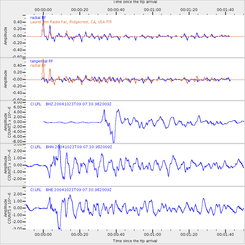
Signal To Noise
| Channel | StoN | STA | LTA |
| CI:LRL: :BHN:20041023T09:07:30.982009Z | 3.173197 | 6.30563E-7 | 1.9871538E-7 |
| CI:LRL: :BHE:20041023T09:07:30.982009Z | 1.9867026 | 5.485942E-7 | 2.7613302E-7 |
| CI:LRL: :BHZ:20041023T09:07:30.982009Z | 11.686347 | 1.838828E-6 | 1.573484E-7 |
| Arrivals |
| Ps | 3.7 SECOND |
| PpPs | 13 SECOND |
| PsPs/PpSs | 16 SECOND |


