You are here: Home > Network List > US - United States National Seismic Network Stations List
> Station WMOK Wichita Mountains, Oklahoma, USA > Earthquake Result Viewer
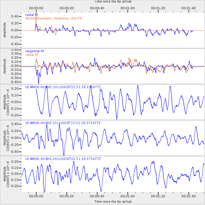
WMOK Wichita Mountains, Oklahoma, USA - Earthquake Result Viewer
*The percent match for this event was below the threshold and hence no stack was calculated.
| Earthquake location: |
Near Coast Of Central Chile |
| Earthquake latitude/longitude: |
-38.0/-73.9 |
| Earthquake time(UTC): |
2011/09/28 (271) 22:40:12 GMT |
| Earthquake Depth: |
10 km |
| Earthquake Magnitude: |
5.5 MW, 5.6 MW |
| Earthquake Catalog/Contributor: |
NEIC PDE/NEIC PDE-M |
|
| Network: |
US United States National Seismic Network |
| Station: |
WMOK Wichita Mountains, Oklahoma, USA |
| Lat/Lon: |
34.74 N/98.78 W |
| Elevation: |
486 m |
|
| Distance: |
75.9 deg |
| Az: |
339.033 deg |
| Baz: |
159.911 deg |
| Ray Param: |
$rayparam |
*The percent match for this event was below the threshold and hence was not used in the summary stack. |
|
| Radial Match: |
54.035927 % |
| Radial Bump: |
400 |
| Transverse Match: |
66.122894 % |
| Transverse Bump: |
400 |
| SOD ConfigId: |
558545 |
| Insert Time: |
2013-09-19 03:43:05.953 +0000 |
| GWidth: |
2.5 |
| Max Bumps: |
400 |
| Tol: |
0.001 |
|
Signal To Noise
| Channel | StoN | STA | LTA |
| US:WMOK:00:BHZ:20110928T22:51:28.373977Z | 0.7958091 | 1.3150486E-7 | 1.6524675E-7 |
| US:WMOK:00:BH1:20110928T22:51:28.373977Z | 1.6668608 | 1.1127997E-7 | 6.67602E-8 |
| US:WMOK:00:BH2:20110928T22:51:28.373977Z | 0.6537206 | 7.361301E-8 | 1.12606216E-7 |
| Arrivals |
| Ps | |
| PpPs | |
| PsPs/PpSs | |


