You are here: Home > Network List > US - United States National Seismic Network Stations List
> Station AMTX Amarillo, Texas, USA > Earthquake Result Viewer
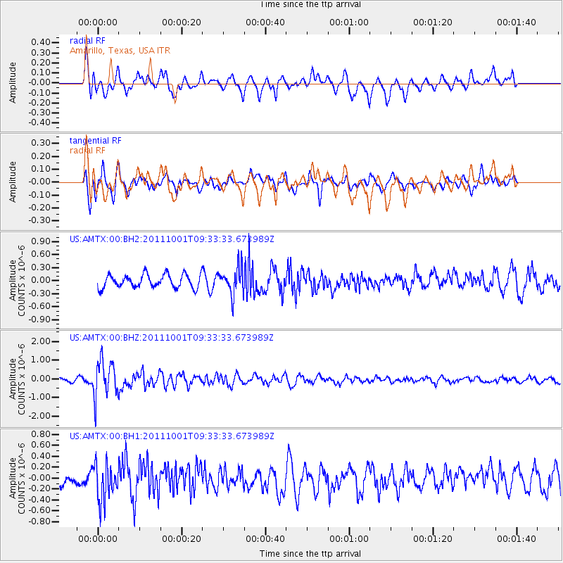
AMTX Amarillo, Texas, USA - Earthquake Result Viewer
*The percent match for this event was below the threshold and hence no stack was calculated.
| Earthquake location: |
Near Islands, Aleutian Islands |
| Earthquake latitude/longitude: |
51.8/172.1 |
| Earthquake time(UTC): |
2011/10/01 (274) 09:23:49 GMT |
| Earthquake Depth: |
10 km |
| Earthquake Magnitude: |
5.8 MB |
| Earthquake Catalog/Contributor: |
NEIC PDE/NEIC PDE-M |
|
| Network: |
US United States National Seismic Network |
| Station: |
AMTX Amarillo, Texas, USA |
| Lat/Lon: |
34.53 N/101.41 W |
| Elevation: |
1010 m |
|
| Distance: |
61.7 deg |
| Az: |
69.345 deg |
| Baz: |
315.236 deg |
| Ray Param: |
$rayparam |
*The percent match for this event was below the threshold and hence was not used in the summary stack. |
|
| Radial Match: |
59.150837 % |
| Radial Bump: |
400 |
| Transverse Match: |
56.522804 % |
| Transverse Bump: |
400 |
| SOD ConfigId: |
558545 |
| Insert Time: |
2013-09-19 03:45:09.368 +0000 |
| GWidth: |
2.5 |
| Max Bumps: |
400 |
| Tol: |
0.001 |
|
Signal To Noise
| Channel | StoN | STA | LTA |
| US:AMTX:00:BHZ:20111001T09:33:33.673989Z | 4.7933693 | 9.985173E-7 | 2.083122E-7 |
| US:AMTX:00:BH1:20111001T09:33:33.673989Z | 2.6957526 | 3.445712E-7 | 1.2782004E-7 |
| US:AMTX:00:BH2:20111001T09:33:33.673989Z | 2.7116091 | 4.3241363E-7 | 1.5946755E-7 |
| Arrivals |
| Ps | |
| PpPs | |
| PsPs/PpSs | |


