You are here: Home > Network List > CN - Canadian National Seismograph Network Stations List
> Station INK INUVIK, NT, CANADA.ANADA > Earthquake Result Viewer
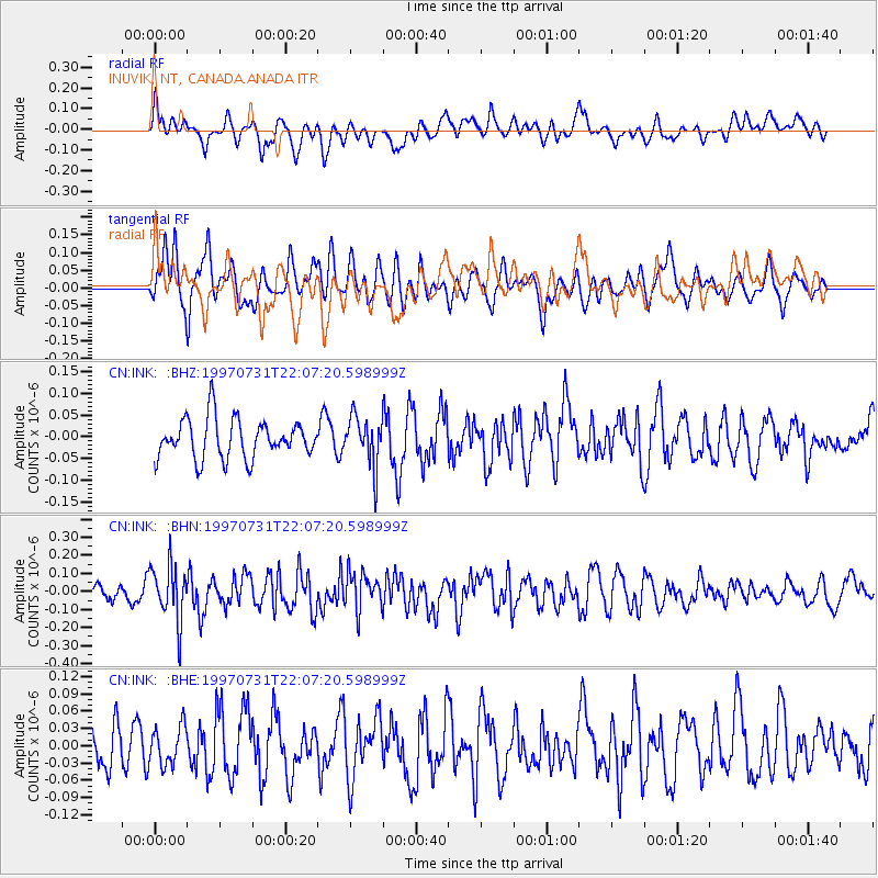
INK INUVIK, NT, CANADA.ANADA - Earthquake Result Viewer
*The percent match for this event was below the threshold and hence no stack was calculated.
| Earthquake location: |
Banda Sea |
| Earthquake latitude/longitude: |
-6.6/130.9 |
| Earthquake time(UTC): |
1997/07/31 (212) 21:54:21 GMT |
| Earthquake Depth: |
59 km |
| Earthquake Magnitude: |
5.9 MB, 5.3 MS, 6.1 UNKNOWN, 6.1 MW |
| Earthquake Catalog/Contributor: |
WHDF/NEIC |
|
| Network: |
CN Canadian National Seismograph Network |
| Station: |
INK INUVIK, NT, CANADA.ANADA |
| Lat/Lon: |
68.31 N/133.52 W |
| Elevation: |
40 m |
|
| Distance: |
98.2 deg |
| Az: |
21.953 deg |
| Baz: |
272.705 deg |
| Ray Param: |
$rayparam |
*The percent match for this event was below the threshold and hence was not used in the summary stack. |
|
| Radial Match: |
64.74705 % |
| Radial Bump: |
400 |
| Transverse Match: |
60.437813 % |
| Transverse Bump: |
400 |
| SOD ConfigId: |
4480 |
| Insert Time: |
2010-02-27 06:26:57.422 +0000 |
| GWidth: |
2.5 |
| Max Bumps: |
400 |
| Tol: |
0.001 |
|
Signal To Noise
| Channel | StoN | STA | LTA |
| CN:INK: :BHN:19970731T22:07:20.598999Z | 2.3116624 | 1.5398018E-7 | 6.6610156E-8 |
| CN:INK: :BHE:19970731T22:07:20.598999Z | 0.8691895 | 3.3355544E-8 | 3.8375457E-8 |
| CN:INK: :BHZ:19970731T22:07:20.598999Z | 1.2634516 | 5.6886815E-8 | 4.502493E-8 |
| Arrivals |
| Ps | |
| PpPs | |
| PsPs/PpSs | |


