You are here: Home > Network List > CN - Canadian National Seismograph Network Stations List
> Station INK INUVIK, NT, CANADA.ANADA > Earthquake Result Viewer
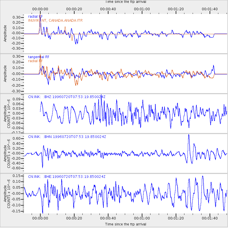
INK INUVIK, NT, CANADA.ANADA - Earthquake Result Viewer
*The percent match for this event was below the threshold and hence no stack was calculated.
| Earthquake location: |
Fiji Islands Region |
| Earthquake latitude/longitude: |
-19.8/-177.6 |
| Earthquake time(UTC): |
1996/07/20 (202) 07:41:15 GMT |
| Earthquake Depth: |
357 km |
| Earthquake Magnitude: |
5.7 MB, 5.9 UNKNOWN, 5.8 MW |
| Earthquake Catalog/Contributor: |
WHDF/NEIC |
|
| Network: |
CN Canadian National Seismograph Network |
| Station: |
INK INUVIK, NT, CANADA.ANADA |
| Lat/Lon: |
68.31 N/133.52 W |
| Elevation: |
40 m |
|
| Distance: |
93.5 deg |
| Az: |
15.03 deg |
| Baz: |
221.05 deg |
| Ray Param: |
$rayparam |
*The percent match for this event was below the threshold and hence was not used in the summary stack. |
|
| Radial Match: |
60.327312 % |
| Radial Bump: |
400 |
| Transverse Match: |
56.825867 % |
| Transverse Bump: |
400 |
| SOD ConfigId: |
4480 |
| Insert Time: |
2010-02-27 06:27:01.383 +0000 |
| GWidth: |
2.5 |
| Max Bumps: |
400 |
| Tol: |
0.001 |
|
Signal To Noise
| Channel | StoN | STA | LTA |
| CN:INK: :BHN:19960720T07:53:19.850024Z | 5.2804613 | 1.8589708E-7 | 3.5204703E-8 |
| CN:INK: :BHE:19960720T07:53:19.850024Z | 1.9839182 | 6.399817E-8 | 3.2258473E-8 |
| CN:INK: :BHZ:19960720T07:53:19.850024Z | 1.2776703 | 4.5262997E-8 | 3.5426194E-8 |
| Arrivals |
| Ps | |
| PpPs | |
| PsPs/PpSs | |


