You are here: Home > Network List > US - United States National Seismic Network Stations List
> Station MNTX Cornudas Mountains, Texas, USA > Earthquake Result Viewer
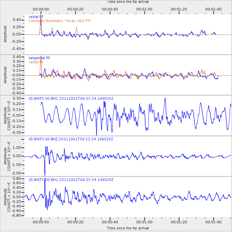
MNTX Cornudas Mountains, Texas, USA - Earthquake Result Viewer
*The percent match for this event was below the threshold and hence no stack was calculated.
| Earthquake location: |
Near Islands, Aleutian Islands |
| Earthquake latitude/longitude: |
51.8/172.1 |
| Earthquake time(UTC): |
2011/10/01 (274) 09:23:49 GMT |
| Earthquake Depth: |
10 km |
| Earthquake Magnitude: |
5.8 MB |
| Earthquake Catalog/Contributor: |
NEIC PDE/NEIC PDE-M |
|
| Network: |
US United States National Seismic Network |
| Station: |
MNTX Cornudas Mountains, Texas, USA |
| Lat/Lon: |
31.70 N/105.38 W |
| Elevation: |
404 m |
|
| Distance: |
61.4 deg |
| Az: |
74.3 deg |
| Baz: |
315.436 deg |
| Ray Param: |
$rayparam |
*The percent match for this event was below the threshold and hence was not used in the summary stack. |
|
| Radial Match: |
54.16123 % |
| Radial Bump: |
366 |
| Transverse Match: |
54.40792 % |
| Transverse Bump: |
400 |
| SOD ConfigId: |
558545 |
| Insert Time: |
2013-09-19 03:46:22.557 +0000 |
| GWidth: |
2.5 |
| Max Bumps: |
400 |
| Tol: |
0.001 |
|
Signal To Noise
| Channel | StoN | STA | LTA |
| US:MNTX:00:BHZ:20111001T09:33:34.149026Z | 5.8754473 | 6.643296E-7 | 1.13068765E-7 |
| US:MNTX:00:BH1:20111001T09:33:34.149026Z | 3.1012895 | 2.7173E-7 | 8.761839E-8 |
| US:MNTX:00:BH2:20111001T09:33:34.149026Z | 0.9043311 | 1.0352204E-7 | 1.1447361E-7 |
| Arrivals |
| Ps | |
| PpPs | |
| PsPs/PpSs | |


