You are here: Home > Network List > CI - Caltech Regional Seismic Network Stations List
> Station LRL Laurel Mtn Radio Fac, Ridgecrest, CA, USA > Earthquake Result Viewer
LRL Laurel Mtn Radio Fac, Ridgecrest, CA, USA - Earthquake Result Viewer

| Earthquake location: |
Near S. Coast Of Honshu, Japan |
| Earthquake latitude/longitude: |
33.1/137.2 |
| Earthquake time(UTC): |
2004/09/08 (252) 14:58:25 GMT |
| Earthquake Depth: |
21 km |
| Earthquake Magnitude: |
6.2 MB, 5.8 MS, 6.2 MW, 6.1 MW |
| Earthquake Catalog/Contributor: |
WHDF/NEIC |
|
| Network: |
CI Caltech Regional Seismic Network |
| Station: |
LRL Laurel Mtn Radio Fac, Ridgecrest, CA, USA |
| Lat/Lon: |
35.48 N/117.68 W |
| Elevation: |
1340 m |
|
| Distance: |
82.2 deg |
| Az: |
52.682 deg |
| Baz: |
305.16 deg |
| Ray Param: |
0.04703591 |
| Estimated Moho Depth: |
30.75 km |
| Estimated Crust Vp/Vs: |
1.81 |
| Assumed Crust Vp: |
6.276 km/s |
| Estimated Crust Vs: |
3.477 km/s |
| Estimated Crust Poisson's Ratio: |
0.28 |
|
| Radial Match: |
93.593735 % |
| Radial Bump: |
380 |
| Transverse Match: |
80.89605 % |
| Transverse Bump: |
400 |
| SOD ConfigId: |
2459 |
| Insert Time: |
2010-02-25 20:39:33.372 +0000 |
| GWidth: |
2.5 |
| Max Bumps: |
400 |
| Tol: |
0.001 |
|
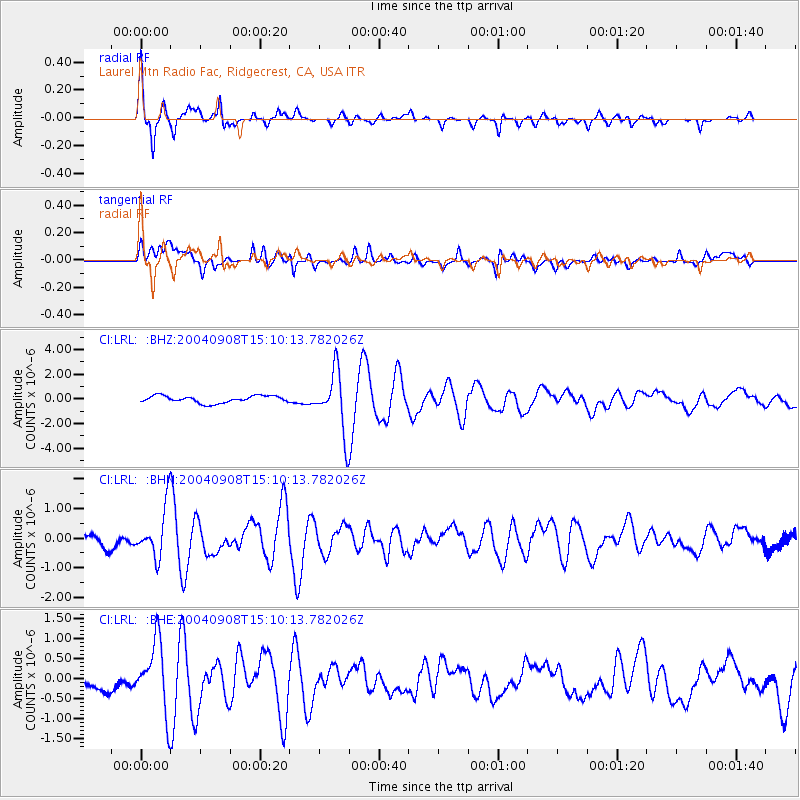
Signal To Noise
| Channel | StoN | STA | LTA |
| CI:LRL: :BHN:20040908T15:10:13.782026Z | 4.4189773 | 8.478104E-7 | 1.918567E-7 |
| CI:LRL: :BHE:20040908T15:10:13.782026Z | 3.5484478 | 8.6414667E-7 | 2.4352806E-7 |
| CI:LRL: :BHZ:20040908T15:10:13.782026Z | 8.573321 | 2.4281394E-6 | 2.8322037E-7 |
| Arrivals |
| Ps | 4.0 SECOND |
| PpPs | 13 SECOND |
| PsPs/PpSs | 17 SECOND |


