You are here: Home > Network List > CN - Canadian National Seismograph Network Stations List
> Station INK INUVIK, NT, CANADA.ANADA > Earthquake Result Viewer
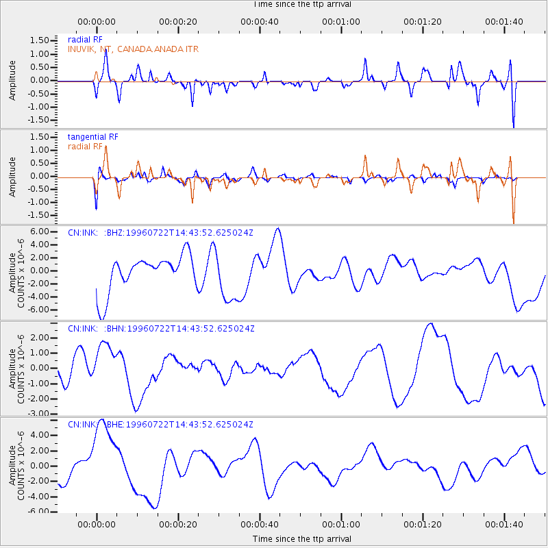
INK INUVIK, NT, CANADA.ANADA - Earthquake Result Viewer
*The percent match for this event was below the threshold and hence no stack was calculated.
| Earthquake location: |
Minahassa Peninsula, Sulawesi |
| Earthquake latitude/longitude: |
1.0/120.5 |
| Earthquake time(UTC): |
1996/07/22 (204) 14:31:05 GMT |
| Earthquake Depth: |
33 km |
| Earthquake Magnitude: |
5.6 MB |
| Earthquake Catalog/Contributor: |
WHDF/NEIC |
|
| Network: |
CN Canadian National Seismograph Network |
| Station: |
INK INUVIK, NT, CANADA.ANADA |
| Lat/Lon: |
68.31 N/133.52 W |
| Elevation: |
40 m |
|
| Distance: |
94.9 deg |
| Az: |
21.019 deg |
| Baz: |
285.297 deg |
| Ray Param: |
$rayparam |
*The percent match for this event was below the threshold and hence was not used in the summary stack. |
|
| Radial Match: |
44.54693 % |
| Radial Bump: |
371 |
| Transverse Match: |
51.916714 % |
| Transverse Bump: |
400 |
| SOD ConfigId: |
4480 |
| Insert Time: |
2010-02-27 06:27:07.584 +0000 |
| GWidth: |
2.5 |
| Max Bumps: |
400 |
| Tol: |
0.001 |
|
Signal To Noise
| Channel | StoN | STA | LTA |
| CN:INK: :BHN:19960722T14:43:52.625024Z | 1.3574163 | 1.3806642E-6 | 1.0171267E-6 |
| CN:INK: :BHE:19960722T14:43:52.625024Z | 3.575209 | 5.090626E-6 | 1.4238682E-6 |
| CN:INK: :BHZ:19960722T14:43:52.625024Z | 1.4030762 | 3.879721E-6 | 2.7651536E-6 |
| Arrivals |
| Ps | |
| PpPs | |
| PsPs/PpSs | |


