You are here: Home > Network List > IU - Global Seismograph Network (GSN - IRIS/USGS) Stations List
> Station HNR Honiara, Solomon Islands > Earthquake Result Viewer
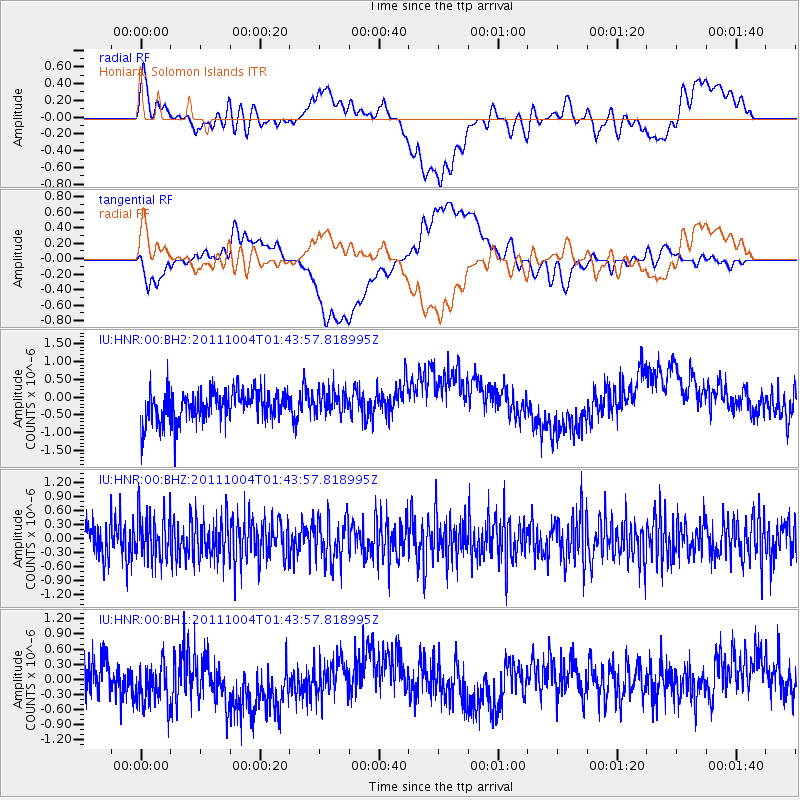
HNR Honiara, Solomon Islands - Earthquake Result Viewer
*The percent match for this event was below the threshold and hence no stack was calculated.
| Earthquake location: |
Bonin Islands, Japan Region |
| Earthquake latitude/longitude: |
26.8/140.4 |
| Earthquake time(UTC): |
2011/10/04 (277) 01:37:29 GMT |
| Earthquake Depth: |
456 km |
| Earthquake Magnitude: |
5.6 MW, 5.7 MW |
| Earthquake Catalog/Contributor: |
NEIC PDE/NEIC PDE-M |
|
| Network: |
IU Global Seismograph Network (GSN - IRIS/USGS) |
| Station: |
HNR Honiara, Solomon Islands |
| Lat/Lon: |
9.44 S/159.95 E |
| Elevation: |
100 m |
|
| Distance: |
40.7 deg |
| Az: |
149.617 deg |
| Baz: |
332.722 deg |
| Ray Param: |
$rayparam |
*The percent match for this event was below the threshold and hence was not used in the summary stack. |
|
| Radial Match: |
35.075886 % |
| Radial Bump: |
400 |
| Transverse Match: |
31.595085 % |
| Transverse Bump: |
400 |
| SOD ConfigId: |
558545 |
| Insert Time: |
2013-09-19 03:48:59.666 +0000 |
| GWidth: |
2.5 |
| Max Bumps: |
400 |
| Tol: |
0.001 |
|
Signal To Noise
| Channel | StoN | STA | LTA |
| IU:HNR:00:BHZ:20111004T01:43:57.818995Z | 1.0897311 | 4.741419E-7 | 4.350999E-7 |
| IU:HNR:00:BH1:20111004T01:43:57.818995Z | 1.590575 | 5.7422494E-7 | 3.6101721E-7 |
| IU:HNR:00:BH2:20111004T01:43:57.818995Z | 0.78950787 | 3.4166428E-7 | 4.3275602E-7 |
| Arrivals |
| Ps | |
| PpPs | |
| PsPs/PpSs | |


