You are here: Home > Network List > US - United States National Seismic Network Stations List
> Station EGMT Eagleton, Montana, USA > Earthquake Result Viewer
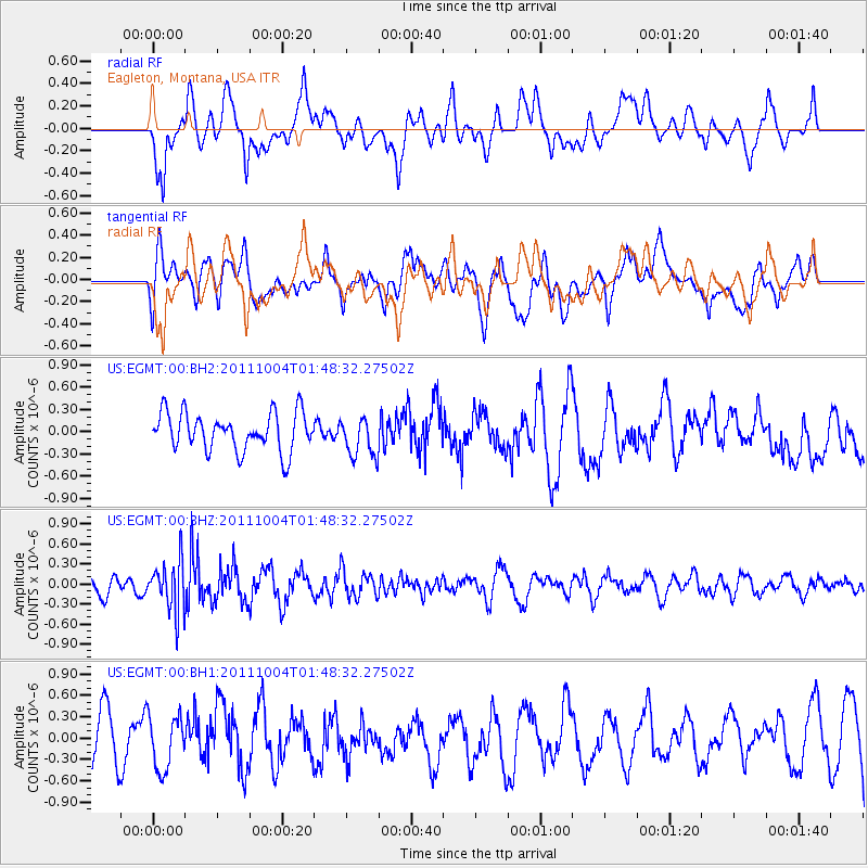
EGMT Eagleton, Montana, USA - Earthquake Result Viewer
*The percent match for this event was below the threshold and hence no stack was calculated.
| Earthquake location: |
Bonin Islands, Japan Region |
| Earthquake latitude/longitude: |
26.8/140.4 |
| Earthquake time(UTC): |
2011/10/04 (277) 01:37:29 GMT |
| Earthquake Depth: |
456 km |
| Earthquake Magnitude: |
5.6 MW, 5.7 MW |
| Earthquake Catalog/Contributor: |
NEIC PDE/NEIC PDE-M |
|
| Network: |
US United States National Seismic Network |
| Station: |
EGMT Eagleton, Montana, USA |
| Lat/Lon: |
48.02 N/109.75 W |
| Elevation: |
1055 m |
|
| Distance: |
82.6 deg |
| Az: |
39.556 deg |
| Baz: |
301.989 deg |
| Ray Param: |
$rayparam |
*The percent match for this event was below the threshold and hence was not used in the summary stack. |
|
| Radial Match: |
61.251728 % |
| Radial Bump: |
400 |
| Transverse Match: |
61.65298 % |
| Transverse Bump: |
400 |
| SOD ConfigId: |
558545 |
| Insert Time: |
2013-09-19 03:49:50.529 +0000 |
| GWidth: |
2.5 |
| Max Bumps: |
400 |
| Tol: |
0.001 |
|
Signal To Noise
| Channel | StoN | STA | LTA |
| US:EGMT:00:BHZ:20111004T01:48:32.27502Z | 1.8099664 | 3.6897302E-7 | 2.0385627E-7 |
| US:EGMT:00:BH1:20111004T01:48:32.27502Z | 0.8507381 | 3.7589976E-7 | 4.4185134E-7 |
| US:EGMT:00:BH2:20111004T01:48:32.27502Z | 1.0547737 | 2.6921825E-7 | 2.5523792E-7 |
| Arrivals |
| Ps | |
| PpPs | |
| PsPs/PpSs | |


