You are here: Home > Network List > CN - Canadian National Seismograph Network Stations List
> Station INK INUVIK, NT, CANADA.ANADA > Earthquake Result Viewer
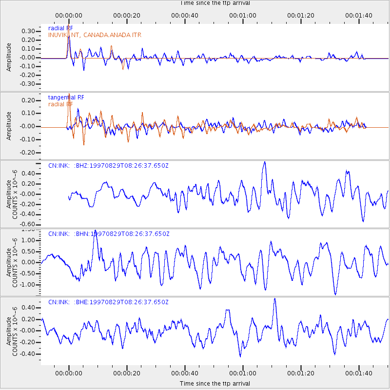
INK INUVIK, NT, CANADA.ANADA - Earthquake Result Viewer
*The percent match for this event was below the threshold and hence no stack was calculated.
| Earthquake location: |
Near N Coast Of New Guinea, P.N.G. |
| Earthquake latitude/longitude: |
-3.6/144.4 |
| Earthquake time(UTC): |
1997/08/29 (241) 08:14:09 GMT |
| Earthquake Depth: |
23 km |
| Earthquake Magnitude: |
5.8 MB, 6.8 MS, 6.6 UNKNOWN, 6.5 MW |
| Earthquake Catalog/Contributor: |
WHDF/NEIC |
|
| Network: |
CN Canadian National Seismograph Network |
| Station: |
INK INUVIK, NT, CANADA.ANADA |
| Lat/Lon: |
68.31 N/133.52 W |
| Elevation: |
40 m |
|
| Distance: |
90.4 deg |
| Az: |
21.61 deg |
| Baz: |
261.373 deg |
| Ray Param: |
$rayparam |
*The percent match for this event was below the threshold and hence was not used in the summary stack. |
|
| Radial Match: |
59.490032 % |
| Radial Bump: |
389 |
| Transverse Match: |
61.569736 % |
| Transverse Bump: |
400 |
| SOD ConfigId: |
4480 |
| Insert Time: |
2010-02-27 06:27:10.819 +0000 |
| GWidth: |
2.5 |
| Max Bumps: |
400 |
| Tol: |
0.001 |
|
Signal To Noise
| Channel | StoN | STA | LTA |
| CN:INK: :BHN:19970829T08:26:37.650Z | 2.0657744 | 4.737777E-7 | 2.2934628E-7 |
| CN:INK: :BHE:19970829T08:26:37.650Z | 1.0720391 | 1.4287653E-7 | 1.3327549E-7 |
| CN:INK: :BHZ:19970829T08:26:37.650Z | 1.0889803 | 1.3495426E-7 | 1.2392718E-7 |
| Arrivals |
| Ps | |
| PpPs | |
| PsPs/PpSs | |


