You are here: Home > Network List > US - United States National Seismic Network Stations List
> Station BOZ Bozeman, Montana, USA > Earthquake Result Viewer
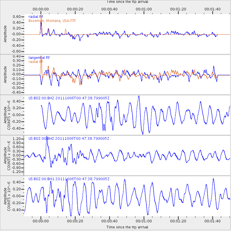
BOZ Bozeman, Montana, USA - Earthquake Result Viewer
*The percent match for this event was below the threshold and hence no stack was calculated.
| Earthquake location: |
Reykjanes Ridge |
| Earthquake latitude/longitude: |
57.9/-32.5 |
| Earthquake time(UTC): |
2011/10/06 (279) 00:39:32 GMT |
| Earthquake Depth: |
10 km |
| Earthquake Magnitude: |
5.6 MW, 5.5 MW, 5.5 MS |
| Earthquake Catalog/Contributor: |
NEIC PDE/NEIC PDE-M |
|
| Network: |
US United States National Seismic Network |
| Station: |
BOZ Bozeman, Montana, USA |
| Lat/Lon: |
45.65 N/111.63 W |
| Elevation: |
1589 m |
|
| Distance: |
47.7 deg |
| Az: |
291.322 deg |
| Baz: |
45.177 deg |
| Ray Param: |
$rayparam |
*The percent match for this event was below the threshold and hence was not used in the summary stack. |
|
| Radial Match: |
51.10997 % |
| Radial Bump: |
400 |
| Transverse Match: |
54.61736 % |
| Transverse Bump: |
400 |
| SOD ConfigId: |
558545 |
| Insert Time: |
2013-09-19 03:51:47.154 +0000 |
| GWidth: |
2.5 |
| Max Bumps: |
400 |
| Tol: |
0.001 |
|
Signal To Noise
| Channel | StoN | STA | LTA |
| US:BOZ:00:BHZ:20111006T00:47:38.799005Z | 2.8618271 | 5.500997E-7 | 1.9221974E-7 |
| US:BOZ:00:BH1:20111006T00:47:38.799005Z | 1.0015306 | 2.0012357E-7 | 1.9981772E-7 |
| US:BOZ:00:BH2:20111006T00:47:38.799005Z | 1.0723557 | 1.9865502E-7 | 1.8525104E-7 |
| Arrivals |
| Ps | |
| PpPs | |
| PsPs/PpSs | |


