You are here: Home > Network List > CN - Canadian National Seismograph Network Stations List
> Station INK INUVIK, NT, CANADA.ANADA > Earthquake Result Viewer
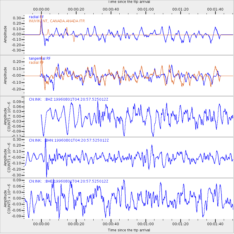
INK INUVIK, NT, CANADA.ANADA - Earthquake Result Viewer
*The percent match for this event was below the threshold and hence no stack was calculated.
| Earthquake location: |
Minahassa Peninsula, Sulawesi |
| Earthquake latitude/longitude: |
-0.0/122.9 |
| Earthquake time(UTC): |
1996/08/01 (214) 04:08:23 GMT |
| Earthquake Depth: |
149 km |
| Earthquake Magnitude: |
5.5 MB, 5.6 UNKNOWN, 5.5 MW |
| Earthquake Catalog/Contributor: |
WHDF/NEIC |
|
| Network: |
CN Canadian National Seismograph Network |
| Station: |
INK INUVIK, NT, CANADA.ANADA |
| Lat/Lon: |
68.31 N/133.52 W |
| Elevation: |
40 m |
|
| Distance: |
95.0 deg |
| Az: |
21.275 deg |
| Baz: |
282.596 deg |
| Ray Param: |
$rayparam |
*The percent match for this event was below the threshold and hence was not used in the summary stack. |
|
| Radial Match: |
54.12407 % |
| Radial Bump: |
368 |
| Transverse Match: |
50.685883 % |
| Transverse Bump: |
400 |
| SOD ConfigId: |
4480 |
| Insert Time: |
2010-02-27 06:27:16.939 +0000 |
| GWidth: |
2.5 |
| Max Bumps: |
400 |
| Tol: |
0.001 |
|
Signal To Noise
| Channel | StoN | STA | LTA |
| CN:INK: :BHN:19960801T04:20:57.525012Z | 2.1506598 | 1.3069793E-7 | 6.077108E-8 |
| CN:INK: :BHE:19960801T04:20:57.525012Z | 0.35270372 | 2.0022867E-8 | 5.676965E-8 |
| CN:INK: :BHZ:19960801T04:20:57.525012Z | 0.7347674 | 3.611758E-8 | 4.9155123E-8 |
| Arrivals |
| Ps | |
| PpPs | |
| PsPs/PpSs | |


