You are here: Home > Network List > CN - Canadian National Seismograph Network Stations List
> Station INK INUVIK, NT, CANADA.ANADA > Earthquake Result Viewer
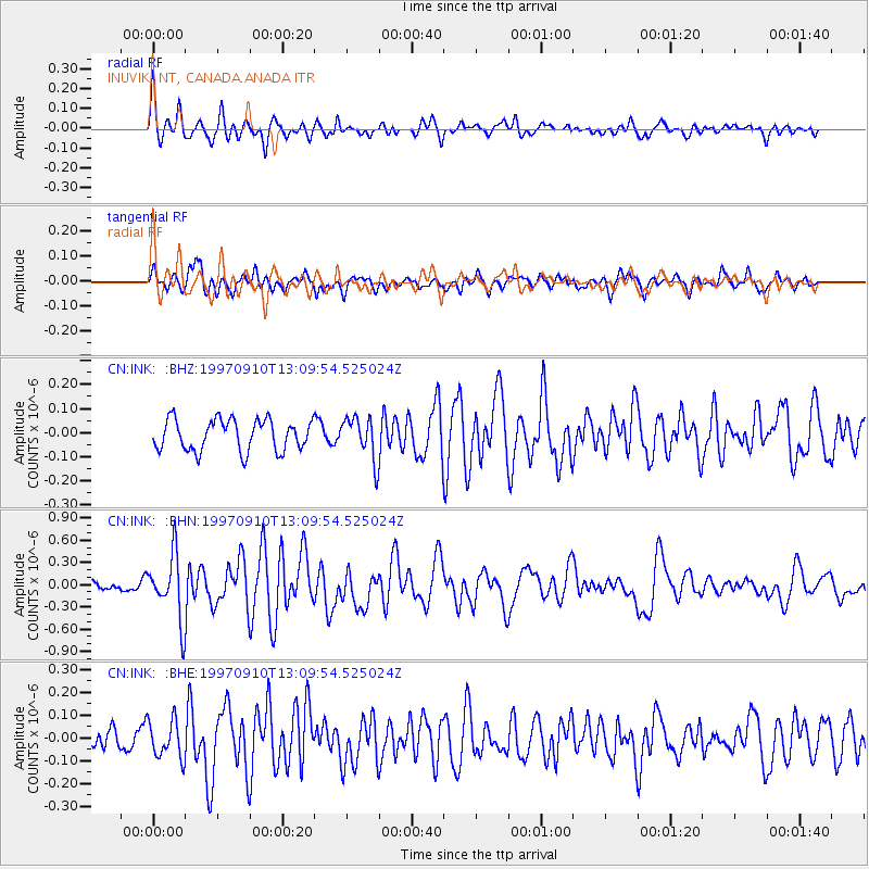
INK INUVIK, NT, CANADA.ANADA - Earthquake Result Viewer
*The percent match for this event was below the threshold and hence no stack was calculated.
| Earthquake location: |
Tonga Islands |
| Earthquake latitude/longitude: |
-21.3/-174.4 |
| Earthquake time(UTC): |
1997/09/10 (253) 12:57:07 GMT |
| Earthquake Depth: |
10 km |
| Earthquake Magnitude: |
5.7 MB, 6.1 MS, 6.1 UNKNOWN, 5.9 MW |
| Earthquake Catalog/Contributor: |
WHDF/NEIC |
|
| Network: |
CN Canadian National Seismograph Network |
| Station: |
INK INUVIK, NT, CANADA.ANADA |
| Lat/Lon: |
68.31 N/133.52 W |
| Elevation: |
40 m |
|
| Distance: |
94.2 deg |
| Az: |
14.118 deg |
| Baz: |
217.706 deg |
| Ray Param: |
$rayparam |
*The percent match for this event was below the threshold and hence was not used in the summary stack. |
|
| Radial Match: |
68.74356 % |
| Radial Bump: |
400 |
| Transverse Match: |
55.774708 % |
| Transverse Bump: |
400 |
| SOD ConfigId: |
4480 |
| Insert Time: |
2010-02-27 06:27:20.190 +0000 |
| GWidth: |
2.5 |
| Max Bumps: |
400 |
| Tol: |
0.001 |
|
Signal To Noise
| Channel | StoN | STA | LTA |
| CN:INK: :BHN:19970910T13:09:54.525024Z | 4.7501807 | 4.3101105E-7 | 9.073572E-8 |
| CN:INK: :BHE:19970910T13:09:54.525024Z | 1.174942 | 8.2290995E-8 | 7.003835E-8 |
| CN:INK: :BHZ:19970910T13:09:54.525024Z | 1.3761567 | 8.8361865E-8 | 6.420916E-8 |
| Arrivals |
| Ps | |
| PpPs | |
| PsPs/PpSs | |


