You are here: Home > Network List > CN - Canadian National Seismograph Network Stations List
> Station INK INUVIK, NT, CANADA.ANADA > Earthquake Result Viewer
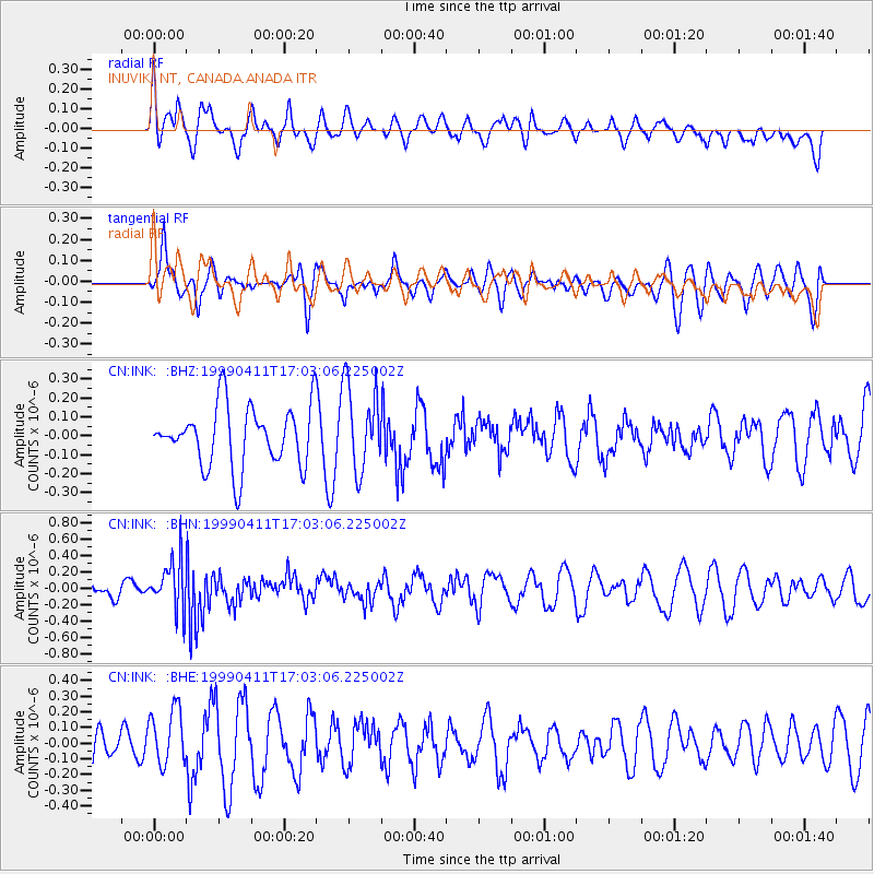
INK INUVIK, NT, CANADA.ANADA - Earthquake Result Viewer
*The percent match for this event was below the threshold and hence no stack was calculated.
| Earthquake location: |
New Britain Region, P.N.G. |
| Earthquake latitude/longitude: |
-6.0/148.5 |
| Earthquake time(UTC): |
1999/04/11 (101) 16:50:39 GMT |
| Earthquake Depth: |
58 km |
| Earthquake Magnitude: |
5.6 MB, 5.7 MS, 6.1 MW, 6.0 MW |
| Earthquake Catalog/Contributor: |
WHDF/NEIC |
|
| Network: |
CN Canadian National Seismograph Network |
| Station: |
INK INUVIK, NT, CANADA.ANADA |
| Lat/Lon: |
68.31 N/133.52 W |
| Elevation: |
40 m |
|
| Distance: |
91.1 deg |
| Az: |
21.328 deg |
| Baz: |
256.653 deg |
| Ray Param: |
$rayparam |
*The percent match for this event was below the threshold and hence was not used in the summary stack. |
|
| Radial Match: |
40.50411 % |
| Radial Bump: |
400 |
| Transverse Match: |
44.18165 % |
| Transverse Bump: |
400 |
| SOD ConfigId: |
4480 |
| Insert Time: |
2010-02-27 06:27:22.908 +0000 |
| GWidth: |
2.5 |
| Max Bumps: |
400 |
| Tol: |
0.001 |
|
Signal To Noise
| Channel | StoN | STA | LTA |
| CN:INK: :BHN:19990411T17:03:06.225002Z | 3.3153749 | 3.0274364E-7 | 9.131506E-8 |
| CN:INK: :BHE:19990411T17:03:06.225002Z | 1.7629746 | 1.7897231E-7 | 1.0151724E-7 |
| CN:INK: :BHZ:19990411T17:03:06.225002Z | 1.4348285 | 2.2657096E-7 | 1.5790805E-7 |
| Arrivals |
| Ps | |
| PpPs | |
| PsPs/PpSs | |


